Noonday geodata
Noonday (Texas) is a populated place; located in United States in America/Chicago (GMT-5) time zone. With population of 777 people, there are 18004 cities with bigger population in this country. Compared to other cities in United States, 88% of cities are located further ↑North; 72.1% of cities are located further →East and 61.5% of cities have higher elevation than Noonday. Note1


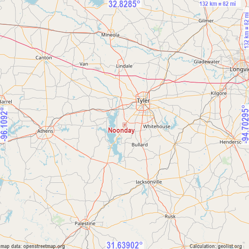
Noonday GPS coordinates[2]
32° 14' 8.556" North, 95° 24' 21.852" West
| Map corner | latitude | longitude |
|---|---|---|
| Upper-left | 32.8285°, | -96.1092° |
| Center: | 32.23571°, | -95.40607° |
| Lower-right: | 31.63902°, | -94.70295° |
| Map W x H: | 132.3×132.3 km | = 82.2×82.2mi |
| max Lat: | 71.29058° ⇑88% North |
| Noonday: | 32.23571° |
| min Lat: | ⇓12% South 19.06759° |
| min Long | Noonday | max Long |
| -171.73463° | -95.40607° | -66.98998° |
| W 27.9%⇐ | ⇒72.1% E |
Elevation
Elevation of Noonday is 147 m = 482 ft, and this is 147.8 m = 485 ft below average elevation for this country.
| Max E: |
3189 m = 10463 ft | 61.5% |
| Avg. | 294.8 m = 967 ft | |
| Noonday | 147 m = 482 ft | |
Min E: |
-60 m = -197 ft | 38.5% |
See also: United States elevation on elevation.city.
Geographical zone
Noonday is located in North temperate zone (between Tropic of Cancer and the Arctic Circle). Distance of this Northern Tropic circle is 978.4 km =607.9 mi to South.| Distance of | km | miles | from Noonday |
|---|---|---|---|
| North Pole | 6422.8 | 3990.9 | to North |
| Arctic Circle | 3816.9 | 2371.7 | to North |
| Tropic Cancer | 978.4 | 607.9 | to South |
| Equator | 3584.3 | 2227.2 | to South |


Nearby cities:
15 places around Noonday: (largest is in red/bold)
• Arp
32.8 km =20.4 mi,  91°
91°
• Berryville
17.5 km =10.9 mi,  200°
200°
• Brownsboro
20.9 km =13 mi,  290°
290°
• Bullard
13.4 km =8.3 mi,  142°
142°
• Chandler
10.6 km =6.6 mi,  319°
319°
• Frankston
22.4 km =13.9 mi, 204°
• Hideaway
28.7 km =17.8 mi,  350°
350°
• Jacksonville
32.8 km =20.4 mi,  157°
157°
• Lindale
31.1 km =19.3 mi,  359°
359°
• Murchison
32.7 km =20.3 mi,  278°
278°
• New Chapel Hill
23.2 km =14.4 mi,  70°
70°
• Troup
28.7 km =17.8 mi,  110°
110°
• Tyler
16.2 km =10.1 mi,  37°
37°
• Whitehouse
17 km =10.6 mi, 93°
• Winona
36.1 km =22.4 mi, 38°
Sources, notices
• [Note1] Compared only with cities in United States existing in our database
• [Src1] Map data: © OpenStreetMap contributors (CC-BY-SA)
• [Src2] Other city data from geonames.org with taken over terms of usage.
• [Src3] Geographical zone / Annual Mean Temperature by Robert A. Rohde @ Wikipedia
