Canyon Lake geodata
Canyon Lake (Texas) is a populated place; located in United States in America/Chicago (GMT-5) time zone. With population of 21,262 people, there are 2373 cities with bigger population in this country. Compared to other cities in United States, 93.7% of cities are located further ↑North; 79% of cities are located further →East and 72% of cities have lower elevation than Canyon Lake. Note1


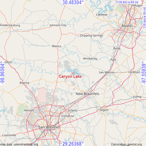
Canyon Lake GPS coordinates[2]
29° 52' 30.792" North, 98° 15' 45.036" West
| Map corner | latitude | longitude |
|---|---|---|
| Upper-left | 30.48304°, | -98.96564° |
| Center: | 29.87522°, | -98.26251° |
| Lower-right: | 29.26368°, | -97.55939° |
| Map W x H: | 135.6×135.6 km | = 84.3×84.3mi |
| max Lat: | 71.29058° ⇑93.7% North |
| Canyon Lake: | 29.87522° |
| min Lat: | ⇓6.3% South 19.06759° |
| min Long | Canyon Lake | max Long |
| -171.73463° | -98.26251° | -66.98998° |
| W 21%⇐ | ⇒79% E |
Elevation
Elevation of Canyon Lake is 296 m = 971 ft, and this is 1.2 m = 4 ft above average elevation for this country.
| Max E: |
3189 m = 10463 ft | 28% |
| Canyon Lake | 296 m 971 ft | |
| Avg. | 294.8 m = 967 ft | |
Min E: |
-60 m = -197 ft | 72% |
See also: United States elevation on elevation.city.
Geographical zone
Canyon Lake is located in North temperate zone (between Tropic of Cancer and the Arctic Circle). Distance of this Northern Tropic circle is 715.9 km =444.8 mi to South.| Distance of | km | miles | from Canyon Lake |
|---|---|---|---|
| North Pole | 6685.2 | 4154 | to North |
| Arctic Circle | 4079.4 | 2534.8 | to North |
| Tropic Cancer | 715.9 | 444.8 | to South |
| Equator | 3321.8 | 2064.1 | to South |


Nearby cities:
15 places around Canyon Lake: (largest is in red/bold)
• Blanco
29.1 km =18.1 mi,  328°
328°
• Bulverde
23.5 km =14.6 mi,  231°
231°
• Cibolo
35 km =21.7 mi,  174°
174°
• Garden Ridge
27.1 km =16.8 mi,  188°
188°
• Lake Dunlap
28.8 km =17.9 mi,  140°
140°
• Live Oak
35.2 km =21.9 mi, 191°
• Marion
35.8 km =22.2 mi,  160°
160°
• New Braunfels
23.3 km =14.5 mi,  145°
145°
• Northcliff
28.5 km =17.7 mi, 172°
• Redwood
34.6 km =21.5 mi,  102°
102°
• San Marcos
31 km =19.3 mi,  88°
88°
• Selma
32.6 km =20.3 mi, 187°
• Timberwood Park
28.1 km =17.5 mi, 227°
• Wimberley
20.8 km =12.9 mi,  49°
49°
• Woodcreek
22.4 km =13.9 mi,  40°
40°
Sources, notices
• [Note1] Compared only with cities in United States existing in our database
• [Src1] Map data: © OpenStreetMap contributors (CC-BY-SA)
• [Src2] Other city data from geonames.org with taken over terms of usage.
• [Src3] Geographical zone / Annual Mean Temperature by Robert A. Rohde @ Wikipedia
