Potosi geodata
Potosi (Texas) is a populated place; located in United States in America/Chicago (GMT-5) time zone. With population of 2,991 people, there are 9652 cities with bigger population in this country. Compared to other cities in United States, 87.7% of cities are located further ↑North; 80.5% of cities are located further →East and 89% of cities have lower elevation than Potosi. Note1


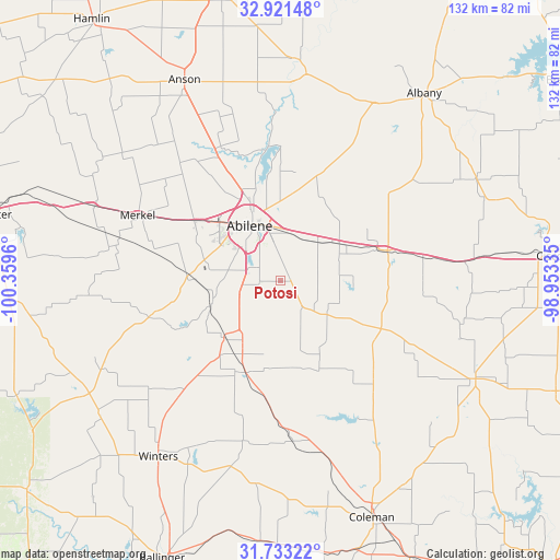
Potosi GPS coordinates[2]
32° 19' 45.48" North, 99° 39' 23.292" West
| Map corner | latitude | longitude |
|---|---|---|
| Upper-left | 32.92148°, | -100.3596° |
| Center: | 32.3293°, | -99.65647° |
| Lower-right: | 31.73322°, | -98.95335° |
| Map W x H: | 132.1×132.1 km | = 82.1×82.1mi |
| max Lat: | 71.29058° ⇑87.7% North |
| Potosi: | 32.3293° |
| min Lat: | ⇓12.3% South 19.06759° |
| min Long | Potosi | max Long |
| -171.73463° | -99.65647° | -66.98998° |
| W 19.5%⇐ | ⇒80.5% E |
Elevation
Elevation of Potosi is 557 m = 1827 ft, and this is 262.2 m = 860 ft above average elevation for this country.
| Max E: |
3189 m = 10463 ft | 11% |
| Potosi | 557 m 1827 ft | |
| Avg. | 294.8 m = 967 ft | |
Min E: |
-60 m = -197 ft | 89% |
See also: United States elevation on elevation.city.
Geographical zone
Potosi is located in North temperate zone (between Tropic of Cancer and the Arctic Circle). Distance of this Northern Tropic circle is 988.8 km =614.4 mi to South.| Distance of | km | miles | from Potosi |
|---|---|---|---|
| North Pole | 6412.4 | 3984.5 | to North |
| Arctic Circle | 3806.5 | 2365.2 | to North |
| Tropic Cancer | 988.8 | 614.4 | to South |
| Equator | 3594.7 | 2233.6 | to South |


Nearby cities:
15 places around Potosi: (largest is in red/bold)
• Abilene
15.1 km =9.4 mi,  331°
331°
• Albany
55.3 km =34.4 mi,  37°
37°
• Anson
52.5 km =32.6 mi, 334°
• Baird
25.7 km =16 mi,  73°
73°
• Cisco
63.9 km =39.7 mi,  84°
84°
• Clyde
17.5 km =10.9 mi,  60°
60°
• Coleman
59.9 km =37.2 mi,  158°
158°
• Cross Plains
51.4 km =31.9 mi,  116°
116°
• Hawley
34.8 km =21.6 mi, 334°
• Merkel
37 km =23 mi,  295°
295°
• Rising Star
70.1 km =43.6 mi,  111°
111°
• Stamford
69.9 km =43.4 mi,  348°
348°
• Tuscola
18.7 km =11.6 mi,  224°
224°
• Tye
24.7 km =15.3 mi,  305°
305°
• Winters
50.5 km =31.4 mi,  214°
214°
Sources, notices
• [Note1] Compared only with cities in United States existing in our database
• [Src1] Map data: © OpenStreetMap contributors (CC-BY-SA)
• [Src2] Other city data from geonames.org with taken over terms of usage.
• [Src3] Geographical zone / Annual Mean Temperature by Robert A. Rohde @ Wikipedia
