Cushing geodata
Cushing (Texas) is a populated place; located in United States in America/Chicago (GMT-5) time zone. With population of 612 people, there are 19566 cities with bigger population in this country. Compared to other cities in United States, 89% of cities are located further ↑North; 70.7% of cities are located further →East and 64.2% of cities have higher elevation than Cushing. Note1


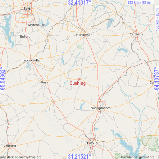
Cushing GPS coordinates[2]
31° 48' 52.632" North, 94° 50' 25.764" West
| Map corner | latitude | longitude |
|---|---|---|
| Upper-left | 32.41017°, | -95.54362° |
| Center: | 31.81462°, | -94.84049° |
| Lower-right: | 31.21521°, | -94.13737° |
| Map W x H: | 132.9×132.9 km | = 82.6×82.6mi |
| max Lat: | 71.29058° ⇑89% North |
| Cushing: | 31.81462° |
| min Lat: | ⇓11% South 19.06759° |
| min Long | Cushing | max Long |
| -171.73463° | -94.84049° | -66.98998° |
| W 29.3%⇐ | ⇒70.7% E |
Elevation
Elevation of Cushing is 132 m = 433 ft, and this is 162.8 m = 534 ft below average elevation for this country.
| Max E: |
3189 m = 10463 ft | 64.2% |
| Avg. | 294.8 m = 967 ft | |
| Cushing | 132 m = 433 ft | |
Min E: |
-60 m = -197 ft | 35.8% |
See also: United States elevation on elevation.city.
Geographical zone
Cushing is located in North temperate zone (between Tropic of Cancer and the Arctic Circle). Distance of this Northern Tropic circle is 931.5 km =578.8 mi to South.| Distance of | km | miles | from Cushing |
|---|---|---|---|
| North Pole | 6469.6 | 4020 | to North |
| Arctic Circle | 3863.7 | 2400.8 | to North |
| Tropic Cancer | 931.5 | 578.8 | to South |
| Equator | 3537.5 | 2198.1 | to South |


Nearby cities:
15 places around Cushing: (largest is in red/bold)
• Alto
28.6 km =17.8 mi,  230°
230°
• Arp
50.1 km =31.1 mi,  335°
335°
• Garrison
33 km =20.5 mi,  88°
88°
• Henderson
37.8 km =23.5 mi,  5°
5°
• Jacksonville
43.9 km =27.3 mi,  292°
292°
• Lufkin
54 km =33.6 mi,  168°
168°
• Nacogdoches
29.3 km =18.2 mi,  143°
143°
• New London
48.1 km =29.9 mi,  348°
348°
• New Summerfield
30.2 km =18.8 mi,  307°
307°
• Overton
52.8 km =32.8 mi, 345°
• Redland
47 km =29.2 mi, 166°
• Rusk
29.3 km =18.2 mi,  265°
265°
• Timpson
43.2 km =26.8 mi,  76°
76°
• Troup
45.2 km =28.1 mi,  324°
324°
• Wells
37.5 km =23.3 mi,  194°
194°
Sources, notices
• [Note1] Compared only with cities in United States existing in our database
• [Src1] Map data: © OpenStreetMap contributors (CC-BY-SA)
• [Src2] Other city data from geonames.org with taken over terms of usage.
• [Src3] Geographical zone / Annual Mean Temperature by Robert A. Rohde @ Wikipedia
