Garrison geodata
Garrison (Texas) is a populated place; located in United States in America/Chicago (GMT-5) time zone. With population of 897 people, there are 17001 cities with bigger population in this country. Compared to other cities in United States, 89% of cities are located further ↑North; 69.9% of cities are located further →East and 66.6% of cities have higher elevation than Garrison. Note1


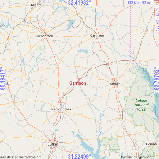
Garrison GPS coordinates[2]
31° 49' 27.624" North, 94° 29' 27.744" West
| Map corner | latitude | longitude |
|---|---|---|
| Upper-left | 32.41982°, | -95.19417° |
| Center: | 31.82434°, | -94.49104° |
| Lower-right: | 31.22499°, | -93.78792° |
| Map W x H: | 132.9×132.9 km | = 82.6×82.6mi |
| max Lat: | 71.29058° ⇑89% North |
| Garrison: | 31.82434° |
| min Lat: | ⇓11% South 19.06759° |
| min Long | Garrison | max Long |
| -171.73463° | -94.49104° | -66.98998° |
| W 30.1%⇐ | ⇒69.9% E |
Elevation
Elevation of Garrison is 120 m = 394 ft, and this is 174.8 m = 573 ft below average elevation for this country.
| Max E: |
3189 m = 10463 ft | 66.6% |
| Avg. | 294.8 m = 967 ft | |
| Garrison | 120 m = 394 ft | |
Min E: |
-60 m = -197 ft | 33.4% |
See also: United States elevation on elevation.city.
Geographical zone
Garrison is located in North temperate zone (between Tropic of Cancer and the Arctic Circle). Distance of this Northern Tropic circle is 932.6 km =579.5 mi to South.| Distance of | km | miles | from Garrison |
|---|---|---|---|
| North Pole | 6468.5 | 4019.3 | to North |
| Arctic Circle | 3862.6 | 2400.1 | to North |
| Tropic Cancer | 932.6 | 579.5 | to South |
| Equator | 3538.5 | 2198.7 | to South |


Nearby cities:
15 places around Garrison: (largest is in red/bold)
• Alto
58.3 km =36.2 mi,  250°
250°
• Beckville
46.7 km =29 mi,  4°
4°
• Carthage
39.8 km =24.7 mi,  21°
21°
• Center
29.7 km =18.5 mi,  96°
96°
• Cushing
33 km =20.5 mi,  268°
268°
• Henderson
46.7 km =29 mi,  321°
321°
• Joaquin
44.1 km =27.4 mi,  69°
69°
• Logansport
49.5 km =30.8 mi, 70°
• Nacogdoches
29.1 km =18.1 mi,  212°
212°
• Redland
51.5 km =32 mi, 205°
• San Augustine
49 km =30.4 mi,  131°
131°
• Tatum
54.7 km =34 mi,  357°
357°
• Tenaha
26.8 km =16.7 mi,  60°
60°
• Timpson
12.6 km =7.8 mi,  45°
45°
• Wells
56.6 km =35.2 mi,  228°
228°
Sources, notices
• [Note1] Compared only with cities in United States existing in our database
• [Src1] Map data: © OpenStreetMap contributors (CC-BY-SA)
• [Src2] Other city data from geonames.org with taken over terms of usage.
• [Src3] Geographical zone / Annual Mean Temperature by Robert A. Rohde @ Wikipedia
