Lufkin geodata
Lufkin (Texas) is a seat of a second-order administrative division; located in United States in America/Chicago (GMT-5) time zone. With population of 36,333 people, there are 1341 cities with bigger population in this country. Compared to other cities in United States, 90% of cities are located further ↑North; 70.5% of cities are located further →East and 70.3% of cities have higher elevation than Lufkin. Note1


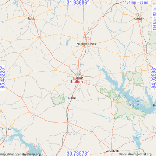
Lufkin GPS coordinates[2]
31° 20' 17.664" North, 94° 43' 44.76" West
| Map corner | latitude | longitude |
|---|---|---|
| Upper-left | 31.93686°, | -95.43223° |
| Center: | 31.33824°, | -94.7291° |
| Lower-right: | 30.73578°, | -94.02598° |
| Map W x H: | 133.5×133.5 km | = 83×83mi |
| max Lat: | 71.29058° ⇑90% North |
| Lufkin: | 31.33824° |
| min Lat: | ⇓10% South 19.06759° |
| min Long | Lufkin | max Long |
| -171.73463° | -94.7291° | -66.98998° |
| W 29.5%⇐ | ⇒70.5% E |
Elevation
Elevation of Lufkin is 99 m = 325 ft, and this is 195.8 m = 642 ft below average elevation for this country.
| Max E: |
3189 m = 10463 ft | 70.3% |
| Avg. | 294.8 m = 967 ft | |
| Lufkin | 99 m = 325 ft | |
Min E: |
-60 m = -197 ft | 29.7% |
See also: United States elevation on elevation.city.
Geographical zone
Lufkin is located in North temperate zone (between Tropic of Cancer and the Arctic Circle). Distance of this Northern Tropic circle is 878.6 km =545.9 mi to South.| Distance of | km | miles | from Lufkin |
|---|---|---|---|
| North Pole | 6522.6 | 4053 | to North |
| Arctic Circle | 3916.7 | 2433.7 | to North |
| Tropic Cancer | 878.6 | 545.9 | to South |
| Equator | 3484.5 | 2165.2 | to South |


Nearby cities:
15 places around Lufkin: (largest is in red/bold)
• Alto
47.6 km =29.6 mi,  316°
316°
• Burke
12.4 km =7.7 mi,  197°
197°
• Colmesneil
56.1 km =34.9 mi,  148°
148°
• Corrigan
39.1 km =24.3 mi,  193°
193°
• Cushing
54 km =33.6 mi,  348°
348°
• Diboll
17.5 km =10.9 mi, 196°
• Groveton
49.2 km =30.6 mi,  230°
230°
• Hickory Creek
56.4 km =35 mi,  274°
274°
• Hudson
5 km =3.1 mi,  249°
249°
• Huntington
16 km =9.9 mi,  114°
114°
• Nacogdoches
30.3 km =18.8 mi,  13°
13°
• Pleasant Hill
37.2 km =23.1 mi, 190°
• Redland
7.4 km =4.6 mi, 5°
• Wells
26.1 km =16.2 mi,  309°
309°
• Zavalla
35 km =21.7 mi,  124°
124°
Sources, notices
• [Note1] Compared only with cities in United States existing in our database
• [Src1] Map data: © OpenStreetMap contributors (CC-BY-SA)
• [Src2] Other city data from geonames.org with taken over terms of usage.
• [Src3] Geographical zone / Annual Mean Temperature by Robert A. Rohde @ Wikipedia
