Alto geodata
Alto (Texas) is a populated place; located in United States in America/Chicago (GMT-5) time zone. With population of 1,223 people, there are 14995 cities with bigger population in this country. Compared to other cities in United States, 89.3% of cities are located further ↑North; 71.3% of cities are located further →East and 63.5% of cities have higher elevation than Alto. Note1


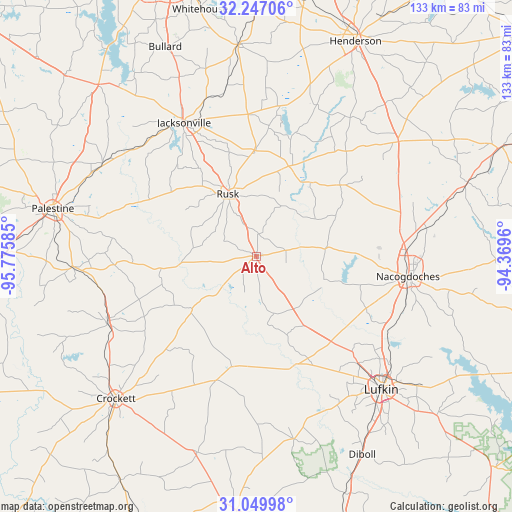
Alto GPS coordinates[2]
31° 39' 1.62" North, 95° 4' 21.792" West
| Map corner | latitude | longitude |
|---|---|---|
| Upper-left | 32.24706°, | -95.77585° |
| Center: | 31.65045°, | -95.07272° |
| Lower-right: | 31.04998°, | -94.3696° |
| Map W x H: | 133.1×133.1 km | = 82.7×82.7mi |
| max Lat: | 71.29058° ⇑89.3% North |
| Alto: | 31.65045° |
| min Lat: | ⇓10.7% South 19.06759° |
| min Long | Alto | max Long |
| -171.73463° | -95.07272° | -66.98998° |
| W 28.7%⇐ | ⇒71.3% E |
Elevation
Elevation of Alto is 136 m = 446 ft, and this is 158.8 m = 521 ft below average elevation for this country.
| Max E: |
3189 m = 10463 ft | 63.5% |
| Avg. | 294.8 m = 967 ft | |
| Alto | 136 m = 446 ft | |
Min E: |
-60 m = -197 ft | 36.5% |
See also: United States elevation on elevation.city.
Geographical zone
Alto is located in North temperate zone (between Tropic of Cancer and the Arctic Circle). Distance of this Northern Tropic circle is 913.3 km =567.5 mi to South.| Distance of | km | miles | from Alto |
|---|---|---|---|
| North Pole | 6487.9 | 4031.4 | to North |
| Arctic Circle | 3882 | 2412.2 | to North |
| Tropic Cancer | 913.3 | 567.5 | to South |
| Equator | 3519.2 | 2186.7 | to South |


Nearby cities:
15 places around Alto: (largest is in red/bold)
• Crockett
51.9 km =32.2 mi,  224°
224°
• Cushing
28.6 km =17.8 mi,  50°
50°
• Elkhart
48 km =29.8 mi,  266°
266°
• Grapeland
42.3 km =26.3 mi,  245°
245°
• Hickory Creek
38.3 km =23.8 mi, 217°
• Hudson
45.9 km =28.5 mi,  142°
142°
• Jacksonville
39.5 km =24.5 mi,  331°
331°
• Lufkin
47.6 km =29.6 mi, 136°
• Nacogdoches
39.8 km =24.7 mi,  97°
97°
• New Summerfield
36.8 km =22.9 mi,  356°
356°
• Palestine
54.2 km =33.7 mi,  283°
283°
• Redland
43.1 km =26.8 mi,  129°
129°
• Rusk
17.8 km =11.1 mi,  335°
335°
• San Pedro
34.8 km =21.6 mi,  236°
236°
• Wells
22 km =13.7 mi,  145°
145°
Sources, notices
• [Note1] Compared only with cities in United States existing in our database
• [Src1] Map data: © OpenStreetMap contributors (CC-BY-SA)
• [Src2] Other city data from geonames.org with taken over terms of usage.
• [Src3] Geographical zone / Annual Mean Temperature by Robert A. Rohde @ Wikipedia
