Stockdale geodata
Stockdale (Texas) is a populated place; located in United States in America/Chicago (GMT-5) time zone. With population of 1,564 people, there are 13425 cities with bigger population in this country. Compared to other cities in United States, 95% of cities are located further ↑North; 78.4% of cities are located further →East and 63.1% of cities have higher elevation than Stockdale. Note1


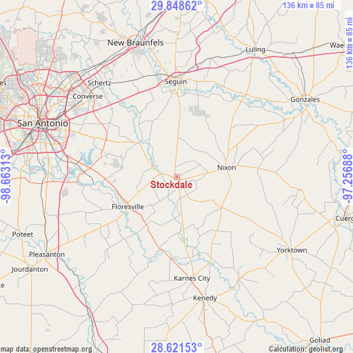
Stockdale GPS coordinates[2]
29° 14' 12.876" North, 97° 57' 36" West
| Map corner | latitude | longitude |
|---|---|---|
| Upper-left | 29.84862°, | -98.66313° |
| Center: | 29.23691°, | -97.96° |
| Lower-right: | 28.62153°, | -97.25688° |
| Map W x H: | 136.4×136.4 km | = 84.8×84.8mi |
| max Lat: | 71.29058° ⇑95% North |
| Stockdale: | 29.23691° |
| min Lat: | ⇓5% South 19.06759° |
| min Long | Stockdale | max Long |
| -171.73463° | -97.96° | -66.98998° |
| W 21.6%⇐ | ⇒78.4% E |
Elevation
Elevation of Stockdale is 138 m = 453 ft, and this is 156.8 m = 514 ft below average elevation for this country.
| Max E: |
3189 m = 10463 ft | 63.1% |
| Avg. | 294.8 m = 967 ft | |
| Stockdale | 138 m = 453 ft | |
Min E: |
-60 m = -197 ft | 36.9% |
See also: United States elevation on elevation.city.
Geographical zone
Stockdale is located in North temperate zone (between Tropic of Cancer and the Arctic Circle). Distance of this Northern Tropic circle is 644.9 km =400.7 mi to South.| Distance of | km | miles | from Stockdale |
|---|---|---|---|
| North Pole | 6756.2 | 4198.1 | to North |
| Arctic Circle | 4150.3 | 2578.9 | to North |
| Tropic Cancer | 644.9 | 400.7 | to South |
| Equator | 3250.8 | 2020 | to South |


Nearby cities:
15 places around Stockdale: (largest is in red/bold)
• China Grove
41.3 km =25.7 mi,  294°
294°
• Elmendorf
36.2 km =22.5 mi,  273°
273°
• Falls City
28.8 km =17.9 mi,  191°
191°
• Floresville
22.2 km =13.8 mi,  238°
238°
• Karnes City
39.6 km =24.6 mi,  171°
171°
• La Vernia
20.1 km =12.5 mi,  311°
311°
• Marion
41.1 km =25.5 mi,  334°
334°
• McQueeney
40.1 km =24.9 mi,  349°
349°
• New Berlin
28.7 km =17.8 mi, 331°
• Nixon
19.3 km =12 mi,  79°
79°
• Poth
22 km =13.7 mi,  212°
212°
• Saint Hedwig
30.5 km =19 mi, 310°
• Santa Clara
34.3 km =21.3 mi, 332°
• Seguin
36.9 km =22.9 mi,  359°
359°
• Smiley
31.6 km =19.6 mi, 83°
Sources, notices
• [Note1] Compared only with cities in United States existing in our database
• [Src1] Map data: © OpenStreetMap contributors (CC-BY-SA)
• [Src2] Other city data from geonames.org with taken over terms of usage.
• [Src3] Geographical zone / Annual Mean Temperature by Robert A. Rohde @ Wikipedia
