La Vernia geodata
La Vernia (Texas) is a populated place; located in United States in America/Chicago (GMT-5) time zone. With population of 1,261 people, there are 14785 cities with bigger population in this country. Compared to other cities in United States, 94.8% of cities are located further ↑North; 78.7% of cities are located further →East and 60.3% of cities have higher elevation than La Vernia. Note1


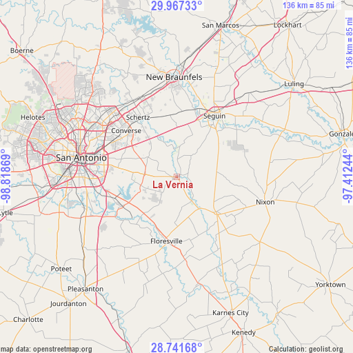
La Vernia GPS coordinates[2]
29° 21' 22.86" North, 98° 6' 56.016" West
| Map corner | latitude | longitude |
|---|---|---|
| Upper-left | 29.96733°, | -98.81869° |
| Center: | 29.35635°, | -98.11556° |
| Lower-right: | 28.74168°, | -97.41244° |
| Map W x H: | 136.3×136.3 km | = 84.7×84.7mi |
| max Lat: | 71.29058° ⇑94.8% North |
| La Vernia: | 29.35635° |
| min Lat: | ⇓5.2% South 19.06759° |
| min Long | La Vernia | max Long |
| -171.73463° | -98.11556° | -66.98998° |
| W 21.3%⇐ | ⇒78.7% E |
Elevation
Elevation of La Vernia is 153 m = 502 ft, and this is 141.8 m = 465 ft below average elevation for this country.
| Max E: |
3189 m = 10463 ft | 60.3% |
| Avg. | 294.8 m = 967 ft | |
| La Vernia | 153 m = 502 ft | |
Min E: |
-60 m = -197 ft | 39.7% |
See also: United States elevation on elevation.city.
Geographical zone
La Vernia is located in North temperate zone (between Tropic of Cancer and the Arctic Circle). Distance of this Northern Tropic circle is 658.2 km =409 mi to South.| Distance of | km | miles | from La Vernia |
|---|---|---|---|
| North Pole | 6742.9 | 4189.8 | to North |
| Arctic Circle | 4137.1 | 2570.7 | to North |
| Tropic Cancer | 658.2 | 409 | to South |
| Equator | 3264.1 | 2028.2 | to South |


Nearby cities:
15 places around La Vernia: (largest is in red/bold)
• China Grove
22.9 km =14.2 mi,  279°
279°
• Cibolo
25.2 km =15.7 mi,  334°
334°
• Converse
26.5 km =16.5 mi,  312°
312°
• Elmendorf
23.8 km =14.8 mi,  242°
242°
• Floresville
25.1 km =15.6 mi,  189°
189°
• Kirby
28.7 km =17.8 mi,  294°
294°
• Marion
24 km =14.9 mi,  354°
354°
• McQueeney
27.4 km =17 mi,  16°
16°
• New Berlin
12.1 km =7.5 mi,  6°
6°
• Saint Hedwig
10.4 km =6.5 mi, 308°
• Santa Clara
17.3 km =10.7 mi,  358°
358°
• Schertz
26.4 km =16.4 mi, 325°
• Seguin
27.8 km =17.3 mi,  31°
31°
• Stockdale
20.1 km =12.5 mi,  131°
131°
• Universal City
27.3 km =17 mi,  321°
321°
Sources, notices
• [Note1] Compared only with cities in United States existing in our database
• [Src1] Map data: © OpenStreetMap contributors (CC-BY-SA)
• [Src2] Other city data from geonames.org with taken over terms of usage.
• [Src3] Geographical zone / Annual Mean Temperature by Robert A. Rohde @ Wikipedia
