Brookside Village geodata
Brookside Village (Texas) is a populated place; located in United States in America/Chicago (GMT-5) time zone. With population of 1,570 people, there are 13401 cities with bigger population in this country. Compared to other cities in United States, 94.4% of cities are located further ↑North; 71.9% of cities are located further →East and 88.2% of cities have higher elevation than Brookside Village. Note1


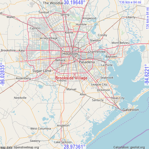
Brookside Village GPS coordinates[2]
29° 35' 12.84" North, 95° 19' 30.792" West
| Map corner | latitude | longitude |
|---|---|---|
| Upper-left | 30.19648°, | -96.02835° |
| Center: | 29.5869°, | -95.32522° |
| Lower-right: | 28.97361°, | -94.6221° |
| Map W x H: | 136×136 km | = 84.5×84.5mi |
| max Lat: | 71.29058° ⇑94.4% North |
| Brookside Village: | 29.5869° |
| min Lat: | ⇓5.6% South 19.06759° |
| min Long | Brookside Villa | max Long |
| -171.73463° | -95.32522° | -66.98998° |
| W 28.1%⇐ | ⇒71.9% E |
Elevation
Elevation of Brookside Village is 20 m = 66 ft, and this is 274.8 m = 902 ft below average elevation for this country.
| Max E: |
3189 m = 10463 ft | 88.2% |
| Avg. | 294.8 m = 967 ft | |
| Brookside Village | 20 m = 66 ft | |
Min E: |
-60 m = -197 ft | 11.8% |
See also: United States elevation on elevation.city.
Geographical zone
Brookside Village is located in North temperate zone (between Tropic of Cancer and the Arctic Circle). Distance of this Northern Tropic circle is 683.8 km =424.9 mi to South.| Distance of | km | miles | from Brookside Village |
|---|---|---|---|
| North Pole | 6717.3 | 4173.9 | to North |
| Arctic Circle | 4111.4 | 2554.7 | to North |
| Tropic Cancer | 683.8 | 424.9 | to South |
| Equator | 3289.8 | 2044.2 | to South |


Nearby cities:
15 places around Brookside Village: (largest is in red/bold)
• Alvin
19.8 km =12.3 mi,  156°
156°
• Arcola
16.9 km =10.5 mi,  233°
233°
• Bellaire
18.5 km =11.5 mi,  315°
315°
• Fresno
13 km =8.1 mi,  245°
245°
• Friendswood
13.6 km =8.5 mi,  118°
118°
• Galena Park
18.7 km =11.6 mi,  29°
29°
• Houston
20 km =12.4 mi,  349°
349°
• Iowa Colony
14.5 km =9 mi,  216°
216°
• Manvel
14.2 km =8.8 mi,  192°
192°
• Pasadena
16.1 km =10 mi,  44°
44°
• Pearland
4.6 km =2.9 mi, 124°
• South Houston
12.1 km =7.5 mi,  45°
45°
• Southside Place
17.1 km =10.6 mi, 320°
• Webster
20.7 km =12.9 mi,  105°
105°
• West University Place
18 km =11.2 mi, 324°
Sources, notices
• [Note1] Compared only with cities in United States existing in our database
• [Src1] Map data: © OpenStreetMap contributors (CC-BY-SA)
• [Src2] Other city data from geonames.org with taken over terms of usage.
• [Src3] Geographical zone / Annual Mean Temperature by Robert A. Rohde @ Wikipedia
