Pearland geodata
Pearland (Texas) is a populated place; located in United States in America/Chicago (GMT-5) time zone. With population of 108,821 people, there are 310 cities with bigger population in this country. Compared to other cities in United States, 94.5% of cities are located further ↑North; 71.8% of cities are located further →East and 89.5% of cities have higher elevation than Pearland. Note1


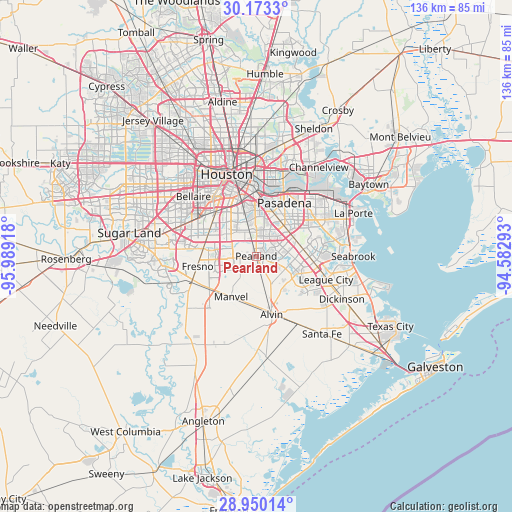
Pearland GPS coordinates[2]
29° 33' 48.852" North, 95° 17' 9.78" West
| Map corner | latitude | longitude |
|---|---|---|
| Upper-left | 30.1733°, | -95.98918° |
| Center: | 29.56357°, | -95.28605° |
| Lower-right: | 28.95014°, | -94.58293° |
| Map W x H: | 136×136 km | = 84.5×84.5mi |
| max Lat: | 71.29058° ⇑94.5% North |
| Pearland: | 29.56357° |
| min Lat: | ⇓5.5% South 19.06759° |
| min Long | Pearland | max Long |
| -171.73463° | -95.28605° | -66.98998° |
| W 28.2%⇐ | ⇒71.8% E |
Elevation
Elevation of Pearland is 17 m = 56 ft, and this is 277.8 m = 911 ft below average elevation for this country.
| Max E: |
3189 m = 10463 ft | 89.5% |
| Avg. | 294.8 m = 967 ft | |
| Pearland | 17 m = 56 ft | |
Min E: |
-60 m = -197 ft | 10.5% |
See also: Pearland elevation on elevation.city.
Geographical zone
Pearland is located in North temperate zone (between Tropic of Cancer and the Arctic Circle). Distance of this Northern Tropic circle is 681.2 km =423.3 mi to South.| Distance of | km | miles | from Pearland |
|---|---|---|---|
| North Pole | 6719.9 | 4175.6 | to North |
| Arctic Circle | 4114 | 2556.3 | to North |
| Tropic Cancer | 681.2 | 423.3 | to South |
| Equator | 3287.2 | 2042.6 | to South |


Nearby cities:
15 places around Pearland: (largest is in red/bold)
• Alvin
16.1 km =10 mi,  165°
165°
• Arcola
18.9 km =11.7 mi,  246°
246°
• Brookside Village
4.6 km =2.9 mi,  304°
304°
• Fresno
15.9 km =9.9 mi,  260°
260°
• Friendswood
9.1 km =5.7 mi,  114°
114°
• Galena Park
19.7 km =12.2 mi,  15°
15°
• Hillcrest
19.2 km =11.9 mi, 172°
• Iowa Colony
15.4 km =9.6 mi,  234°
234°
• League City
19.5 km =12.1 mi, 108°
• Manvel
13.2 km =8.2 mi,  211°
211°
• Nassau Bay
19 km =11.8 mi,  96°
96°
• Pasadena
16 km =9.9 mi,  27°
27°
• South Houston
12.1 km =7.5 mi, 23°
• Southside Place
21.5 km =13.4 mi,  317°
317°
• Webster
16.5 km =10.3 mi, 100°
Sources, notices
• [Note1] Compared only with cities in United States existing in our database
• [Src1] Map data: © OpenStreetMap contributors (CC-BY-SA)
• [Src2] Other city data from geonames.org with taken over terms of usage.
• [Src3] Geographical zone / Annual Mean Temperature by Robert A. Rohde @ Wikipedia
