Geronimo geodata
Geronimo (Texas) is a populated place; located in United States in America/Chicago (GMT-5) time zone. With population of 1,032 people, there are 16071 cities with bigger population in this country. Compared to other cities in United States, 94.2% of cities are located further ↑North; 78.4% of cities are located further →East and 54.8% of cities have higher elevation than Geronimo. Note1


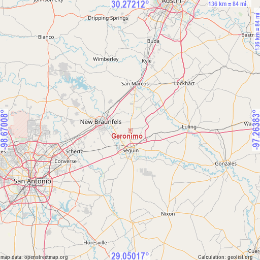
Geronimo GPS coordinates[2]
29° 39' 46.8" North, 97° 58' 1.02" West
| Map corner | latitude | longitude |
|---|---|---|
| Upper-left | 30.27212°, | -98.67008° |
| Center: | 29.663°, | -97.96695° |
| Lower-right: | 29.05017°, | -97.26383° |
| Map W x H: | 135.9×135.9 km | = 84.4×84.4mi |
| max Lat: | 71.29058° ⇑94.2% North |
| Geronimo: | 29.663° |
| min Lat: | ⇓5.8% South 19.06759° |
| min Long | Geronimo | max Long |
| -171.73463° | -97.96695° | -66.98998° |
| W 21.6%⇐ | ⇒78.4% E |
Elevation
Elevation of Geronimo is 181 m = 594 ft, and this is 113.8 m = 373 ft below average elevation for this country.
| Max E: |
3189 m = 10463 ft | 54.8% |
| Avg. | 294.8 m = 967 ft | |
| Geronimo | 181 m = 594 ft | |
Min E: |
-60 m = -197 ft | 45.2% |
See also: United States elevation on elevation.city.
Geographical zone
Geronimo is located in North temperate zone (between Tropic of Cancer and the Arctic Circle). Distance of this Northern Tropic circle is 692.3 km =430.2 mi to South.| Distance of | km | miles | from Geronimo |
|---|---|---|---|
| North Pole | 6708.8 | 4168.7 | to North |
| Arctic Circle | 4103 | 2549.5 | to North |
| Tropic Cancer | 692.3 | 430.2 | to South |
| Equator | 3298.2 | 2049.4 | to South |


Nearby cities:
15 places around Geronimo: (largest is in red/bold)
• Cibolo
27.5 km =17.1 mi,  245°
245°
• Kingsbury
13.5 km =8.4 mi,  97°
97°
• Lake Dunlap
10.3 km =6.4 mi,  277°
277°
• Luling
30.9 km =19.2 mi,  86°
86°
• Marion
19.6 km =12.2 mi,  238°
238°
• Martindale
23.7 km =14.7 mi,  30°
30°
• McQueeney
10.2 km =6.3 mi,  219°
219°
• New Berlin
25.6 km =15.9 mi,  210°
210°
• New Braunfels
15.9 km =9.9 mi,  286°
286°
• Northcliff
25.3 km =15.7 mi,  259°
259°
• Redwood
17.2 km =10.7 mi,  18°
18°
• San Marcos
24.6 km =15.3 mi,  5°
5°
• Santa Clara
22.5 km =14 mi, 221°
• Schertz
31.8 km =19.8 mi, 247°
• Seguin
10.5 km =6.5 mi,  178°
178°
Sources, notices
• [Note1] Compared only with cities in United States existing in our database
• [Src1] Map data: © OpenStreetMap contributors (CC-BY-SA)
• [Src2] Other city data from geonames.org with taken over terms of usage.
• [Src3] Geographical zone / Annual Mean Temperature by Robert A. Rohde @ Wikipedia
