Redwood geodata
Redwood (Texas) is a populated place; located in United States in America/Chicago (GMT-5) time zone. With population of 4,338 people, there are 7828 cities with bigger population in this country. Compared to other cities in United States, 93.9% of cities are located further ↑North; 78.3% of cities are located further →East and 56.9% of cities have higher elevation than Redwood. Note1


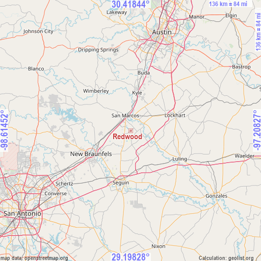
Redwood GPS coordinates[2]
29° 48' 36.792" North, 97° 54' 41.004" West
| Map corner | latitude | longitude |
|---|---|---|
| Upper-left | 30.41844°, | -98.61452° |
| Center: | 29.81022°, | -97.91139° |
| Lower-right: | 29.19828°, | -97.20827° |
| Map W x H: | 135.7×135.7 km | = 84.3×84.3mi |
| max Lat: | 71.29058° ⇑93.9% North |
| Redwood: | 29.81022° |
| min Lat: | ⇓6.1% South 19.06759° |
| min Long | Redwood | max Long |
| -171.73463° | -97.91139° | -66.98998° |
| W 21.7%⇐ | ⇒78.3% E |
Elevation
Elevation of Redwood is 171 m = 561 ft, and this is 123.8 m = 406 ft below average elevation for this country.
| Max E: |
3189 m = 10463 ft | 56.9% |
| Avg. | 294.8 m = 967 ft | |
| Redwood | 171 m = 561 ft | |
Min E: |
-60 m = -197 ft | 43.1% |
See also: United States elevation on elevation.city.
Geographical zone
Redwood is located in North temperate zone (between Tropic of Cancer and the Arctic Circle). Distance of this Northern Tropic circle is 708.7 km =440.4 mi to South.| Distance of | km | miles | from Redwood |
|---|---|---|---|
| North Pole | 6692.5 | 4158.5 | to North |
| Arctic Circle | 4086.6 | 2539.3 | to North |
| Tropic Cancer | 708.7 | 440.4 | to South |
| Equator | 3314.6 | 2059.6 | to South |


Nearby cities:
15 places around Redwood: (largest is in red/bold)
• Geronimo
17.2 km =10.7 mi,  198°
198°
• Kingsbury
19.7 km =12.2 mi,  155°
155°
• Kyle
20.2 km =12.6 mi,  9°
9°
• Lake Dunlap
21.6 km =13.4 mi,  226°
226°
• Lockhart
24.7 km =15.3 mi,  70°
70°
• Luling
29.3 km =18.2 mi,  119°
119°
• Martindale
7.9 km =4.9 mi,  60°
60°
• McQueeney
27 km =16.8 mi,  205°
205°
• Mountain City
25.3 km =15.7 mi, 5°
• New Braunfels
23.8 km =14.8 mi,  239°
239°
• Niederwald
28.3 km =17.6 mi,  38°
38°
• San Marcos
8.6 km =5.3 mi,  340°
340°
• Seguin
27.3 km =17 mi,  190°
190°
• Uhland
20.4 km =12.7 mi, 36°
• Wimberley
27.6 km =17.1 mi,  319°
319°
Sources, notices
• [Note1] Compared only with cities in United States existing in our database
• [Src1] Map data: © OpenStreetMap contributors (CC-BY-SA)
• [Src2] Other city data from geonames.org with taken over terms of usage.
• [Src3] Geographical zone / Annual Mean Temperature by Robert A. Rohde @ Wikipedia
