Luling geodata
Luling (Texas) is a populated place; located in United States in America/Chicago (GMT-5) time zone. With population of 5,764 people, there are 6564 cities with bigger population in this country. Compared to other cities in United States, 94.2% of cities are located further ↑North; 77.6% of cities are located further →East and 64.8% of cities have higher elevation than Luling. Note1


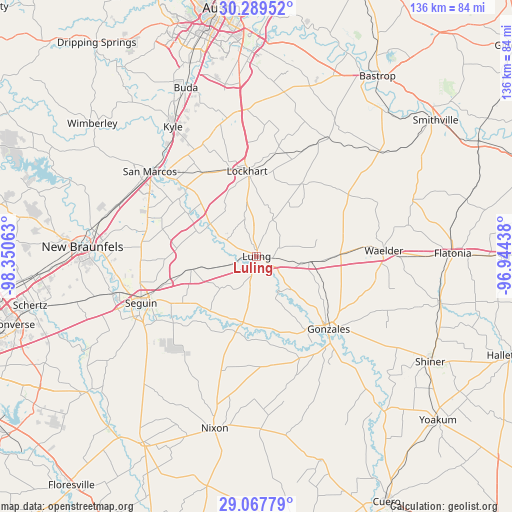
Luling GPS coordinates[2]
29° 40' 49.836" North, 97° 38' 51" West
| Map corner | latitude | longitude |
|---|---|---|
| Upper-left | 30.28952°, | -98.35063° |
| Center: | 29.68051°, | -97.6475° |
| Lower-right: | 29.06779°, | -96.94438° |
| Map W x H: | 135.8×135.8 km | = 84.4×84.4mi |
| max Lat: | 71.29058° ⇑94.2% North |
| Luling: | 29.68051° |
| min Lat: | ⇓5.8% South 19.06759° |
| min Long | Luling | max Long |
| -171.73463° | -97.6475° | -66.98998° |
| W 22.4%⇐ | ⇒77.6% E |
Elevation
Elevation of Luling is 129 m = 423 ft, and this is 165.8 m = 544 ft below average elevation for this country.
| Max E: |
3189 m = 10463 ft | 64.8% |
| Avg. | 294.8 m = 967 ft | |
| Luling | 129 m = 423 ft | |
Min E: |
-60 m = -197 ft | 35.2% |
See also: United States elevation on elevation.city.
Geographical zone
Luling is located in North temperate zone (between Tropic of Cancer and the Arctic Circle). Distance of this Northern Tropic circle is 694.2 km =431.4 mi to South.| Distance of | km | miles | from Luling |
|---|---|---|---|
| North Pole | 6706.9 | 4167.5 | to North |
| Arctic Circle | 4101 | 2548.2 | to North |
| Tropic Cancer | 694.2 | 431.4 | to South |
| Equator | 3300.2 | 2050.6 | to South |


Nearby cities:
15 places around Luling: (largest is in red/bold)
• Geronimo
30.9 km =19.2 mi,  266°
266°
• Gonzales
27.4 km =17 mi,  136°
136°
• Kingsbury
17.8 km =11.1 mi,  258°
258°
• Kyle
40.8 km =25.4 mi,  327°
327°
• Lake Dunlap
41 km =25.5 mi, 269°
• Lockhart
22.8 km =14.2 mi,  354°
354°
• Martindale
26.2 km =16.3 mi,  314°
314°
• McQueeney
38.6 km =24 mi, 255°
• Mustang Ridge
42.1 km =26.2 mi, 354°
• Niederwald
37.4 km =23.2 mi, 348°
• Redwood
29.3 km =18.2 mi,  299°
299°
• San Marcos
36.2 km =22.5 mi, 308°
• Seguin
33.1 km =20.6 mi,  247°
247°
• Uhland
33.6 km =20.9 mi,  336°
336°
• Waelder
33.7 km =20.9 mi,  87°
87°
Sources, notices
• [Note1] Compared only with cities in United States existing in our database
• [Src1] Map data: © OpenStreetMap contributors (CC-BY-SA)
• [Src2] Other city data from geonames.org with taken over terms of usage.
• [Src3] Geographical zone / Annual Mean Temperature by Robert A. Rohde @ Wikipedia
