Gholson geodata
Gholson (Texas) is a populated place; located in United States in America/Chicago (GMT-5) time zone. With population of 1,076 people, there are 15807 cities with bigger population in this country. Compared to other cities in United States, 89.2% of cities are located further ↑North; 76.3% of cities are located further →East and 63.7% of cities have higher elevation than Gholson. Note1


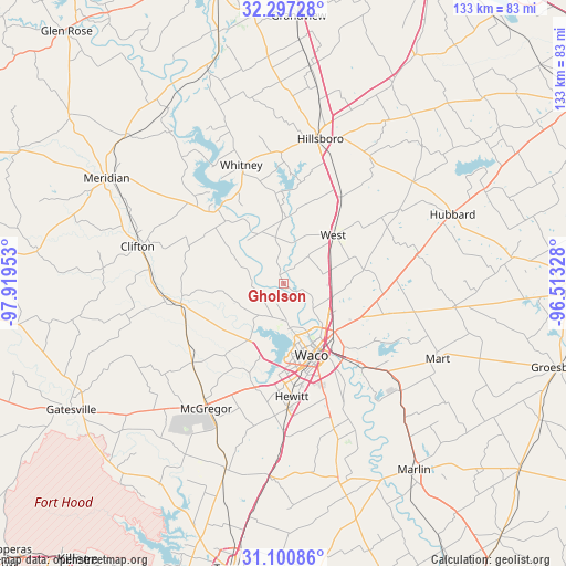
Gholson GPS coordinates[2]
31° 42' 3.6" North, 97° 12' 59.04" West
| Map corner | latitude | longitude |
|---|---|---|
| Upper-left | 32.29728°, | -97.91953° |
| Center: | 31.701°, | -97.2164° |
| Lower-right: | 31.10086°, | -96.51328° |
| Map W x H: | 133×133 km | = 82.6×82.6mi |
| max Lat: | 71.29058° ⇑89.2% North |
| Gholson: | 31.701° |
| min Lat: | ⇓10.8% South 19.06759° |
| min Long | Gholson | max Long |
| -171.73463° | -97.2164° | -66.98998° |
| W 23.7%⇐ | ⇒76.3% E |
Elevation
Elevation of Gholson is 135 m = 443 ft, and this is 159.8 m = 524 ft below average elevation for this country.
| Max E: |
3189 m = 10463 ft | 63.7% |
| Avg. | 294.8 m = 967 ft | |
| Gholson | 135 m = 443 ft | |
Min E: |
-60 m = -197 ft | 36.3% |
See also: United States elevation on elevation.city.
Geographical zone
Gholson is located in North temperate zone (between Tropic of Cancer and the Arctic Circle). Distance of this Northern Tropic circle is 918.9 km =571 mi to South.| Distance of | km | miles | from Gholson |
|---|---|---|---|
| North Pole | 6482.2 | 4027.9 | to North |
| Arctic Circle | 3876.4 | 2408.7 | to North |
| Tropic Cancer | 918.9 | 571 | to South |
| Equator | 3524.8 | 2190.2 | to South |


Nearby cities:
15 places around Gholson: (largest is in red/bold)
• Bellmead
15.7 km =9.8 mi,  139°
139°
• Beverly
20.8 km =12.9 mi,  160°
160°
• Beverly Hills
20.8 km =12.9 mi, 163°
• Crawford
28.4 km =17.6 mi,  229°
229°
• Hallsburg
30.5 km =19 mi,  126°
126°
• Hewitt
26.6 km =16.5 mi,  175°
175°
• Lacy-Lakeview
13.4 km =8.3 mi, 126°
• Laguna Park
23.4 km =14.5 mi,  318°
318°
• Northcrest
13.2 km =8.2 mi,  122°
122°
• Robinson
27.7 km =17.2 mi, 159°
• Valley Mills
24.6 km =15.3 mi,  259°
259°
• Waco
18.1 km =11.2 mi, 158°
• West
16.3 km =10.1 mi,  46°
46°
• Whitney
29.6 km =18.4 mi,  340°
340°
• Woodway
21.7 km =13.5 mi, 177°
Sources, notices
• [Note1] Compared only with cities in United States existing in our database
• [Src1] Map data: © OpenStreetMap contributors (CC-BY-SA)
• [Src2] Other city data from geonames.org with taken over terms of usage.
• [Src3] Geographical zone / Annual Mean Temperature by Robert A. Rohde @ Wikipedia
