Crawford geodata
Crawford (Texas) is a populated place; located in United States in America/Chicago (GMT-5) time zone. With population of 741 people, there are 18297 cities with bigger population in this country. Compared to other cities in United States, 89.6% of cities are located further ↑North; 77% of cities are located further →East and 54.4% of cities have lower elevation than Crawford. Note1


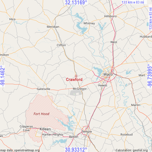
Crawford GPS coordinates[2]
31° 32' 3.588" North, 97° 26' 35.052" West
| Map corner | latitude | longitude |
|---|---|---|
| Upper-left | 32.13169°, | -98.1462° |
| Center: | 31.53433°, | -97.44307° |
| Lower-right: | 30.93312°, | -96.73995° |
| Map W x H: | 133.3×133.3 km | = 82.8×82.8mi |
| max Lat: | 71.29058° ⇑89.6% North |
| Crawford: | 31.53433° |
| min Lat: | ⇓10.4% South 19.06759° |
| min Long | Crawford | max Long |
| -171.73463° | -97.44307° | -66.98998° |
| W 23%⇐ | ⇒77% E |
Elevation
Elevation of Crawford is 216 m = 709 ft, and this is 78.8 m = 259 ft below average elevation for this country.
| Max E: |
3189 m = 10463 ft | 45.6% |
| Avg. | 294.8 m = 967 ft | |
| Crawford | 216 m = 709 ft | |
Min E: |
-60 m = -197 ft | 54.4% |
See also: United States elevation on elevation.city.
Geographical zone
Crawford is located in North temperate zone (between Tropic of Cancer and the Arctic Circle). Distance of this Northern Tropic circle is 900.4 km =559.5 mi to South.| Distance of | km | miles | from Crawford |
|---|---|---|---|
| North Pole | 6500.8 | 4039.4 | to North |
| Arctic Circle | 3894.9 | 2420.2 | to North |
| Tropic Cancer | 900.4 | 559.5 | to South |
| Equator | 3506.3 | 2178.7 | to South |


Nearby cities:
15 places around Crawford: (largest is in red/bold)
• Ames
31.9 km =19.8 mi,  267°
267°
• Beverly
28.6 km =17.8 mi,  92°
92°
• Beverly Hills
27.4 km =17 mi, 92°
• Bruceville-Eddy
31.3 km =19.4 mi,  144°
144°
• Clifton
30.3 km =18.8 mi,  335°
335°
• Fort Gates
29.2 km =18.1 mi,  239°
239°
• Gatesville
30.6 km =19 mi,  248°
248°
• Gholson
28.4 km =17.6 mi,  49°
49°
• Hewitt
24.8 km =15.4 mi,  108°
108°
• Lorena
27.1 km =16.8 mi,  127°
127°
• McGregor
10.5 km =6.5 mi,  162°
162°
• Moody
26.3 km =16.3 mi, 162°
• Valley Mills
14.2 km =8.8 mi,  348°
348°
• Waco
28.1 km =17.5 mi, 86°
• Woodway
22.8 km =14.2 mi,  97°
97°
Sources, notices
• [Note1] Compared only with cities in United States existing in our database
• [Src1] Map data: © OpenStreetMap contributors (CC-BY-SA)
• [Src2] Other city data from geonames.org with taken over terms of usage.
• [Src3] Geographical zone / Annual Mean Temperature by Robert A. Rohde @ Wikipedia
