Valley Mills geodata
Valley Mills (Texas) is a populated place; located in United States in America/Chicago (GMT-5) time zone. With population of 1,177 people, there are 15248 cities with bigger population in this country. Compared to other cities in United States, 89.3% of cities are located further ↑North; 77.1% of cities are located further →East and 53.6% of cities have higher elevation than Valley Mills. Note1


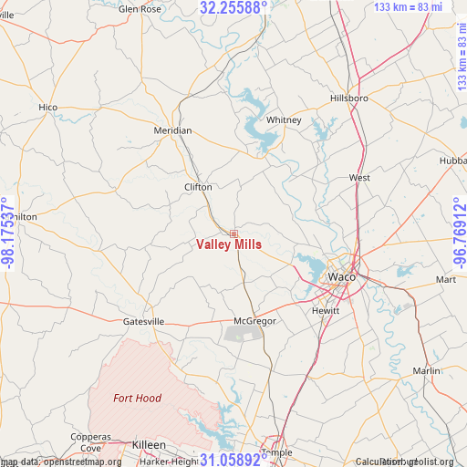
Valley Mills GPS coordinates[2]
31° 39' 33.588" North, 97° 28' 20.064" West
| Map corner | latitude | longitude |
|---|---|---|
| Upper-left | 32.25588°, | -98.17537° |
| Center: | 31.65933°, | -97.47224° |
| Lower-right: | 31.05892°, | -96.76912° |
| Map W x H: | 133.1×133.1 km | = 82.7×82.7mi |
| max Lat: | 71.29058° ⇑89.3% North |
| Valley Mills: | 31.65933° |
| min Lat: | ⇓10.7% South 19.06759° |
| min Long | Valley Mills | max Long |
| -171.73463° | -97.47224° | -66.98998° |
| W 22.9%⇐ | ⇒77.1% E |
Elevation
Elevation of Valley Mills is 185 m = 607 ft, and this is 109.8 m = 360 ft below average elevation for this country.
| Max E: |
3189 m = 10463 ft | 53.6% |
| Avg. | 294.8 m = 967 ft | |
| Valley Mills | 185 m = 607 ft | |
Min E: |
-60 m = -197 ft | 46.4% |
See also: United States elevation on elevation.city.
Geographical zone
Valley Mills is located in North temperate zone (between Tropic of Cancer and the Arctic Circle). Distance of this Northern Tropic circle is 914.3 km =568.1 mi to South.| Distance of | km | miles | from Valley Mills |
|---|---|---|---|
| North Pole | 6486.9 | 4030.8 | to North |
| Arctic Circle | 3881 | 2411.5 | to North |
| Tropic Cancer | 914.3 | 568.1 | to South |
| Equator | 3520.2 | 2187.4 | to South |


Nearby cities:
15 places around Valley Mills: (largest is in red/bold)
• Ames
32.9 km =20.4 mi,  242°
242°
• Bellmead
35.2 km =21.9 mi,  101°
101°
• Beverly
34.7 km =21.6 mi,  115°
115°
• Beverly Hills
33.8 km =21 mi, 116°
• Clifton
16.9 km =10.5 mi,  324°
324°
• Crawford
14.2 km =8.8 mi,  168°
168°
• Gholson
24.6 km =15.3 mi,  79°
79°
• Hewitt
34.1 km =21.2 mi,  129°
129°
• Lacy-Lakeview
35.1 km =21.8 mi, 95°
• Laguna Park
23.9 km =14.9 mi,  21°
21°
• McGregor
24.7 km =15.3 mi, 165°
• Meridian
34.1 km =21.2 mi,  329°
329°
• Northcrest
35.4 km =22 mi,  94°
94°
• Waco
33.2 km =20.6 mi,  111°
111°
• Woodway
30.5 km =19 mi, 123°
Sources, notices
• [Note1] Compared only with cities in United States existing in our database
• [Src1] Map data: © OpenStreetMap contributors (CC-BY-SA)
• [Src2] Other city data from geonames.org with taken over terms of usage.
• [Src3] Geographical zone / Annual Mean Temperature by Robert A. Rohde @ Wikipedia
