Goliad geodata
Goliad (Texas) is a seat of a second-order administrative division; located in United States in America/Chicago (GMT-5) time zone. With population of 1,986 people, there are 11979 cities with bigger population in this country. Compared to other cities in United States, 95.7% of cities are located further ↑North; 76.8% of cities are located further →East and 78.2% of cities have higher elevation than Goliad. Note1


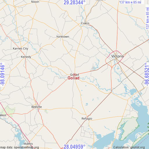
Goliad GPS coordinates[2]
28° 40' 5.988" North, 97° 23' 17.988" West
| Map corner | latitude | longitude |
|---|---|---|
| Upper-left | 29.28344°, | -98.09146° |
| Center: | 28.66833°, | -97.38833° |
| Lower-right: | 28.04959°, | -96.68521° |
| Map W x H: | 137.2×137.2 km | = 85.3×85.3mi |
| max Lat: | 71.29058° ⇑95.7% North |
| Goliad: | 28.66833° |
| min Lat: | ⇓4.3% South 19.06759° |
| min Long | Goliad | max Long |
| -171.73463° | -97.38833° | -66.98998° |
| W 23.2%⇐ | ⇒76.8% E |
Elevation
Elevation of Goliad is 55 m = 180 ft, and this is 239.8 m = 787 ft below average elevation for this country.
| Max E: |
3189 m = 10463 ft | 78.2% |
| Avg. | 294.8 m = 967 ft | |
| Goliad | 55 m = 180 ft | |
Min E: |
-60 m = -197 ft | 21.8% |
See also: United States elevation on elevation.city.
Geographical zone
Goliad is located in North temperate zone (between Tropic of Cancer and the Arctic Circle). Distance of this Northern Tropic circle is 581.7 km =361.5 mi to South.| Distance of | km | miles | from Goliad |
|---|---|---|---|
| North Pole | 6819.4 | 4237.4 | to North |
| Arctic Circle | 4213.6 | 2618.2 | to North |
| Tropic Cancer | 581.7 | 361.5 | to South |
| Equator | 3187.6 | 1980.7 | to South |


Nearby cities:
15 places around Goliad: (largest is in red/bold)
• Beeville
46.2 km =28.7 mi,  229°
229°
• Bloomington
48.4 km =30.1 mi,  92°
92°
• Blue Berry Hill
49.5 km =30.8 mi, 231°
• Cuero
48.3 km =30 mi,  11°
11°
• Karnes City
55.5 km =34.5 mi,  295°
295°
• Kenedy
47.9 km =29.8 mi,  290°
290°
• Pettus
40.8 km =25.4 mi,  262°
262°
• Placedo
54.7 km =34 mi, 87°
• Quail Creek
32.2 km =20 mi,  68°
68°
• Refugio
41.9 km =26 mi,  164°
164°
• Runge
39.7 km =24.7 mi,  307°
307°
• Skidmore
54.4 km =33.8 mi,  212°
212°
• Victoria
40.5 km =25.2 mi, 67°
• Woodsboro
48.3 km =30 mi,  172°
172°
• Yorktown
36.5 km =22.7 mi,  342°
342°
Sources, notices
• [Note1] Compared only with cities in United States existing in our database
• [Src1] Map data: © OpenStreetMap contributors (CC-BY-SA)
• [Src2] Other city data from geonames.org with taken over terms of usage.
• [Src3] Geographical zone / Annual Mean Temperature by Robert A. Rohde @ Wikipedia
