Blue Berry Hill geodata
Blue Berry Hill (Texas) is a populated place; located in United States in America/Chicago (GMT-5) time zone. With population of 866 people, there are 17228 cities with bigger population in this country. Compared to other cities in United States, 96.1% of cities are located further ↑North; 77.9% of cities are located further →East and 72.1% of cities have higher elevation than Blue Berry Hill. Note1


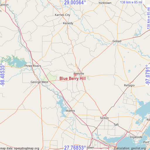
Blue Berry Hill GPS coordinates[2]
28° 23' 20.004" North, 97° 46' 55.992" West
| Map corner | latitude | longitude |
|---|---|---|
| Upper-left | 29.00564°, | -98.48535° |
| Center: | 28.38889°, | -97.78222° |
| Lower-right: | 27.76853°, | -97.0791° |
| Map W x H: | 137.6×137.6 km | = 85.5×85.5mi |
| max Lat: | 71.29058° ⇑96.1% North |
| Blue Berry Hill: | 28.38889° |
| min Lat: | ⇓3.9% South 19.06759° |
| min Long | Blue Berry Hill | max Long |
| -171.73463° | -97.78222° | -66.98998° |
| W 22.1%⇐ | ⇒77.9% E |
Elevation
Elevation of Blue Berry Hill is 88 m = 289 ft, and this is 206.8 m = 678 ft below average elevation for this country.
| Max E: |
3189 m = 10463 ft | 72.1% |
| Avg. | 294.8 m = 967 ft | |
| Blue Berry Hill | 88 m = 289 ft | |
Min E: |
-60 m = -197 ft | 27.9% |
See also: United States elevation on elevation.city.
Geographical zone
Blue Berry Hill is located in North temperate zone (between Tropic of Cancer and the Arctic Circle). Distance of this Northern Tropic circle is 550.6 km =342.1 mi to South.| Distance of | km | miles | from Blue Berry Hill |
|---|---|---|---|
| North Pole | 6850.5 | 4256.7 | to North |
| Arctic Circle | 4244.6 | 2637.5 | to North |
| Tropic Cancer | 550.6 | 342.1 | to South |
| Equator | 3156.5 | 1961.4 | to South |


Nearby cities:
15 places around Blue Berry Hill: (largest is in red/bold)
• Beeville
3.4 km =2.1 mi,  67°
67°
• George West
33.4 km =20.8 mi,  259°
259°
• Goliad
49.5 km =30.8 mi,  51°
51°
• Kenedy
48.3 km =30 mi,  352°
352°
• Lake City
35.9 km =22.3 mi,  196°
196°
• Lakeshore Gardens-Hidden Acres
30.4 km =18.9 mi,  194°
194°
• Mathis
33 km =20.5 mi, 187°
• Orange Grove
50.4 km =31.3 mi, 197°
• Pettus
25.6 km =15.9 mi,  355°
355°
• Refugio
50.5 km =31.4 mi,  100°
100°
• Saint Paul
39.1 km =24.3 mi,  145°
145°
• Sinton
47.4 km =29.5 mi, 145°
• Skidmore
17.7 km =11 mi, 147°
• Three Rivers
39.9 km =24.8 mi,  281°
281°
• Woodsboro
48.2 km =30 mi,  110°
110°
Sources, notices
• [Note1] Compared only with cities in United States existing in our database
• [Src1] Map data: © OpenStreetMap contributors (CC-BY-SA)
• [Src2] Other city data from geonames.org with taken over terms of usage.
• [Src3] Geographical zone / Annual Mean Temperature by Robert A. Rohde @ Wikipedia
