Beeville geodata
Beeville (Texas) is a seat of a second-order administrative division; located in United States in America/Chicago (GMT-5) time zone. With population of 13,277 people, there are 3604 cities with bigger population in this country. Compared to other cities in United States, 96.1% of cities are located further ↑North; 77.9% of cities are located further →East and 75.3% of cities have higher elevation than Beeville. Note1


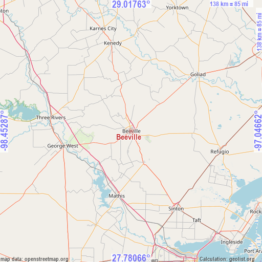
Beeville GPS coordinates[2]
28° 24' 3.42" North, 97° 44' 59.064" West
| Map corner | latitude | longitude |
|---|---|---|
| Upper-left | 29.01763°, | -98.45287° |
| Center: | 28.40095°, | -97.74974° |
| Lower-right: | 27.78066°, | -97.04662° |
| Map W x H: | 137.5×137.5 km | = 85.4×85.4mi |
| max Lat: | 71.29058° ⇑96.1% North |
| Beeville: | 28.40095° |
| min Lat: | ⇓3.9% South 19.06759° |
| min Long | Beeville | max Long |
| -171.73463° | -97.74974° | -66.98998° |
| W 22.1%⇐ | ⇒77.9% E |
Elevation
Elevation of Beeville is 70 m = 230 ft, and this is 224.8 m = 738 ft below average elevation for this country.
| Max E: |
3189 m = 10463 ft | 75.3% |
| Avg. | 294.8 m = 967 ft | |
| Beeville | 70 m = 230 ft | |
Min E: |
-60 m = -197 ft | 24.7% |
See also: United States elevation on elevation.city.
Geographical zone
Beeville is located in North temperate zone (between Tropic of Cancer and the Arctic Circle). Distance of this Northern Tropic circle is 552 km =343 mi to South.| Distance of | km | miles | from Beeville |
|---|---|---|---|
| North Pole | 6849.2 | 4255.9 | to North |
| Arctic Circle | 4243.3 | 2636.7 | to North |
| Tropic Cancer | 552 | 343 | to South |
| Equator | 3157.9 | 1962.2 | to South |


Nearby cities:
15 places around Beeville: (largest is in red/bold)
• Blue Berry Hill
3.4 km =2.1 mi,  247°
247°
• George West
36.8 km =22.9 mi,  258°
258°
• Goliad
46.2 km =28.7 mi,  49°
49°
• Kenedy
47.5 km =29.5 mi,  348°
348°
• Lake City
38.2 km =23.7 mi,  200°
200°
• Lakeshore Gardens-Hidden Acres
32.6 km =20.3 mi, 199°
• Mathis
34.9 km =21.7 mi,  192°
192°
• Odem
52.7 km =32.7 mi,  161°
161°
• Pettus
24.7 km =15.3 mi, 348°
• Refugio
47.6 km =29.6 mi,  102°
102°
• Saint Paul
38.5 km =23.9 mi,  150°
150°
• Sinton
46.9 km =29.1 mi, 149°
• Skidmore
17.5 km =10.9 mi, 158°
• Three Rivers
42.8 km =26.6 mi,  278°
278°
• Woodsboro
45.8 km =28.5 mi,  113°
113°
Sources, notices
• [Note1] Compared only with cities in United States existing in our database
• [Src1] Map data: © OpenStreetMap contributors (CC-BY-SA)
• [Src2] Other city data from geonames.org with taken over terms of usage.
• [Src3] Geographical zone / Annual Mean Temperature by Robert A. Rohde @ Wikipedia
