Golinda geodata
Golinda (Texas) is a populated place; located in United States in America/Chicago (GMT-5) time zone. With population of 557 people, there are 20192 cities with bigger population in this country. Compared to other cities in United States, 89.9% of cities are located further ↑North; 75.9% of cities are located further →East and 61.1% of cities have higher elevation than Golinda. Note1


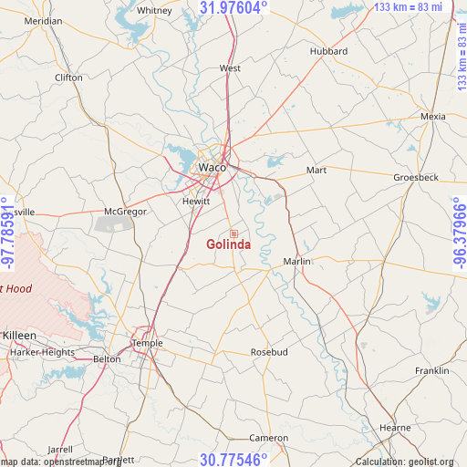
Golinda GPS coordinates[2]
31° 22' 39.612" North, 97° 4' 58.008" West
| Map corner | latitude | longitude |
|---|---|---|
| Upper-left | 31.97604°, | -97.78591° |
| Center: | 31.37767°, | -97.08278° |
| Lower-right: | 30.77546°, | -96.37966° |
| Map W x H: | 133.5×133.5 km | = 83×83mi |
| max Lat: | 71.29058° ⇑89.9% North |
| Golinda: | 31.37767° |
| min Lat: | ⇓10.1% South 19.06759° |
| min Long | Golinda | max Long |
| -171.73463° | -97.08278° | -66.98998° |
| W 24.1%⇐ | ⇒75.9% E |
Elevation
Elevation of Golinda is 149 m = 489 ft, and this is 145.8 m = 478 ft below average elevation for this country.
| Max E: |
3189 m = 10463 ft | 61.1% |
| Avg. | 294.8 m = 967 ft | |
| Golinda | 149 m = 489 ft | |
Min E: |
-60 m = -197 ft | 38.9% |
See also: United States elevation on elevation.city.
Geographical zone
Golinda is located in North temperate zone (between Tropic of Cancer and the Arctic Circle). Distance of this Northern Tropic circle is 883 km =548.7 mi to South.| Distance of | km | miles | from Golinda |
|---|---|---|---|
| North Pole | 6518.2 | 4050.2 | to North |
| Arctic Circle | 3912.3 | 2431 | to North |
| Tropic Cancer | 883 | 548.7 | to South |
| Equator | 3488.9 | 2167.9 | to South |


Nearby cities:
15 places around Golinda: (largest is in red/bold)
• Bellmead
24.2 km =15 mi,  354°
354°
• Beverly
17.3 km =10.7 mi,  341°
341°
• Beverly Hills
17.4 km =10.8 mi, 337°
• Bruceville-Eddy
18 km =11.2 mi,  243°
243°
• Chilton
11 km =6.8 mi,  170°
170°
• Hallsburg
21.6 km =13.4 mi,  33°
33°
• Hewitt
14.3 km =8.9 mi,  311°
311°
• Lorena
12.6 km =7.8 mi,  274°
274°
• Lott
19.9 km =12.4 mi, 167°
• Marlin
19.3 km =12 mi,  114°
114°
• Moody
27.6 km =17.1 mi,  253°
253°
• Riesel
18.6 km =11.6 mi,  54°
54°
• Robinson
10.5 km =6.5 mi, 343°
• Waco
20 km =12.4 mi, 342°
• Woodway
18.4 km =11.4 mi,  320°
320°
Sources, notices
• [Note1] Compared only with cities in United States existing in our database
• [Src1] Map data: © OpenStreetMap contributors (CC-BY-SA)
• [Src2] Other city data from geonames.org with taken over terms of usage.
• [Src3] Geographical zone / Annual Mean Temperature by Robert A. Rohde @ Wikipedia
