Lott geodata
Lott (Texas) is a populated place; located in United States in America/Chicago (GMT-5) time zone. With population of 726 people, there are 18438 cities with bigger population in this country. Compared to other cities in United States, 90.3% of cities are located further ↑North; 75.8% of cities are located further →East and 58.2% of cities have higher elevation than Lott. Note1


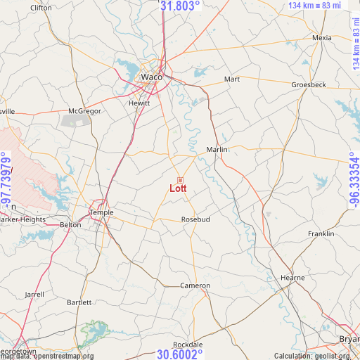
Lott GPS coordinates[2]
31° 12' 12.636" North, 97° 2' 11.976" West
| Map corner | latitude | longitude |
|---|---|---|
| Upper-left | 31.803°, | -97.73979° |
| Center: | 31.20351°, | -97.03666° |
| Lower-right: | 30.6002°, | -96.33354° |
| Map W x H: | 133.7×133.7 km | = 83.1×83.1mi |
| max Lat: | 71.29058° ⇑90.3% North |
| Lott: | 31.20351° |
| min Lat: | ⇓9.7% South 19.06759° |
| min Long | Lott | max Long |
| -171.73463° | -97.03666° | -66.98998° |
| W 24.2%⇐ | ⇒75.8% E |
Elevation
Elevation of Lott is 164 m = 538 ft, and this is 130.8 m = 429 ft below average elevation for this country.
| Max E: |
3189 m = 10463 ft | 58.2% |
| Avg. | 294.8 m = 967 ft | |
| Lott | 164 m = 538 ft | |
Min E: |
-60 m = -197 ft | 41.8% |
See also: United States elevation on elevation.city.
Geographical zone
Lott is located in North temperate zone (between Tropic of Cancer and the Arctic Circle). Distance of this Northern Tropic circle is 863.6 km =536.6 mi to South.| Distance of | km | miles | from Lott |
|---|---|---|---|
| North Pole | 6537.6 | 4062.3 | to North |
| Arctic Circle | 3931.7 | 2443 | to North |
| Tropic Cancer | 863.6 | 536.6 | to South |
| Equator | 3469.5 | 2155.8 | to South |


Nearby cities:
15 places around Lott: (largest is in red/bold)
• Blue Ridge
29.2 km =18.1 mi,  73°
73°
• Bremond
34.5 km =21.4 mi,  97°
97°
• Bruceville-Eddy
23.4 km =14.5 mi,  298°
298°
• Chilton
8.9 km =5.5 mi,  342°
342°
• Golinda
19.9 km =12.4 mi,  347°
347°
• Hewitt
32.5 km =20.2 mi,  332°
332°
• Lorena
26.5 km =16.5 mi,  320°
320°
• Marlin
17.4 km =10.8 mi,  49°
49°
• Moody
33 km =20.5 mi,  290°
290°
• Riesel
32 km =19.9 mi,  19°
19°
• Robinson
30.3 km =18.8 mi, 345°
• Rogers
35.2 km =21.9 mi,  210°
210°
• Rosebud
15.5 km =9.6 mi,  159°
159°
• Temple
31.4 km =19.5 mi,  248°
248°
• Troy
25.3 km =15.7 mi,  270°
270°
Sources, notices
• [Note1] Compared only with cities in United States existing in our database
• [Src1] Map data: © OpenStreetMap contributors (CC-BY-SA)
• [Src2] Other city data from geonames.org with taken over terms of usage.
• [Src3] Geographical zone / Annual Mean Temperature by Robert A. Rohde @ Wikipedia
