Bruceville-Eddy geodata
Bruceville-Eddy (Texas) is a populated place; located in United States in America/Chicago (GMT-5) time zone. With population of 1,497 people, there are 13666 cities with bigger population in this country. Compared to other cities in United States, 90.1% of cities are located further ↑North; 76.4% of cities are located further →East and 53.7% of cities have lower elevation than Bruceville-Eddy. Note1


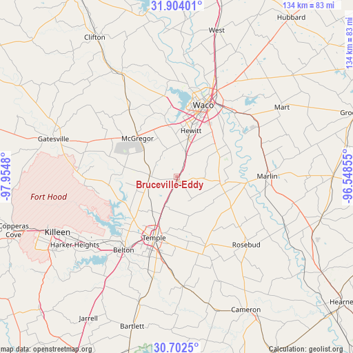
Bruceville-Eddy GPS coordinates[2]
31° 18' 18.612" North, 97° 15' 6.012" West
| Map corner | latitude | longitude |
|---|---|---|
| Upper-left | 31.90401°, | -97.9548° |
| Center: | 31.30517°, | -97.25167° |
| Lower-right: | 30.7025°, | -96.54855° |
| Map W x H: | 133.6×133.6 km | = 83×83mi |
| max Lat: | 71.29058° ⇑90.1% North |
| Bruceville-Eddy: | 31.30517° |
| min Lat: | ⇓9.9% South 19.06759° |
| min Long | Bruceville-Eddy | max Long |
| -171.73463° | -97.25167° | -66.98998° |
| W 23.6%⇐ | ⇒76.4% E |
Elevation
Elevation of Bruceville-Eddy is 213 m = 699 ft, and this is 81.8 m = 268 ft below average elevation for this country.
| Max E: |
3189 m = 10463 ft | 46.3% |
| Avg. | 294.8 m = 967 ft | |
| Bruceville-Eddy | 213 m = 699 ft | |
Min E: |
-60 m = -197 ft | 53.7% |
See also: United States elevation on elevation.city.
Geographical zone
Bruceville-Eddy is located in North temperate zone (between Tropic of Cancer and the Arctic Circle). Distance of this Northern Tropic circle is 874.9 km =543.6 mi to South.| Distance of | km | miles | from Bruceville-Eddy |
|---|---|---|---|
| North Pole | 6526.3 | 4055.3 | to North |
| Arctic Circle | 3920.4 | 2436 | to North |
| Tropic Cancer | 874.9 | 543.6 | to South |
| Equator | 3480.8 | 2162.9 | to South |


Nearby cities:
15 places around Bruceville-Eddy: (largest is in red/bold)
• Beverly
26.6 km =16.5 mi,  23°
23°
• Beverly Hills
25.8 km =16 mi, 21°
• Chilton
18 km =11.2 mi,  98°
98°
• Golinda
18 km =11.2 mi,  63°
63°
• Hewitt
18.3 km =11.4 mi, 16°
• Lorena
9.7 km =6 mi, 20°
• Lott
23.4 km =14.5 mi,  118°
118°
• McGregor
21.5 km =13.4 mi,  315°
315°
• Moody
10.4 km =6.5 mi,  271°
271°
• Morgans Point Resort
26.6 km =16.5 mi,  229°
229°
• Robinson
22.3 km =13.9 mi,  35°
35°
• Temple
24.6 km =15.3 mi,  200°
200°
• Troy
12 km =7.5 mi, 203°
• Waco
28.9 km =18 mi, 20°
• Woodway
22.8 km =14.2 mi,  11°
11°
Sources, notices
• [Note1] Compared only with cities in United States existing in our database
• [Src1] Map data: © OpenStreetMap contributors (CC-BY-SA)
• [Src2] Other city data from geonames.org with taken over terms of usage.
• [Src3] Geographical zone / Annual Mean Temperature by Robert A. Rohde @ Wikipedia
