Grapevine geodata
Grapevine (Texas) is a populated place; located in United States in America/Chicago (GMT-5) time zone. With population of 51,404 people, there are 924 cities with bigger population in this country. Compared to other cities in United States, 85.4% of cities are located further ↑North; 75.9% of cities are located further →East and 50.2% of cities have lower elevation than Grapevine. Note1


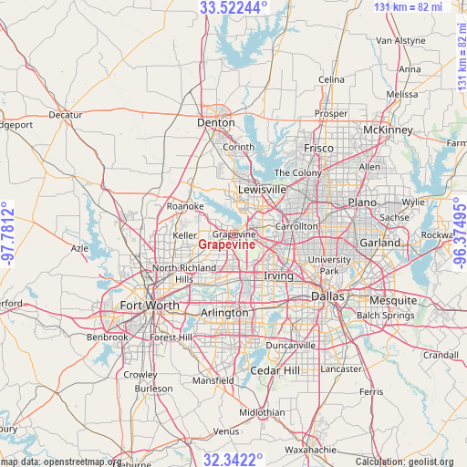
Grapevine GPS coordinates[2]
32° 56' 3.444" North, 97° 4' 41.052" West
| Map corner | latitude | longitude |
|---|---|---|
| Upper-left | 33.52244°, | -97.7812° |
| Center: | 32.93429°, | -97.07807° |
| Lower-right: | 32.3422°, | -96.37495° |
| Map W x H: | 131.2×131.2 km | = 81.5×81.5mi |
| max Lat: | 71.29058° ⇑85.4% North |
| Grapevine: | 32.93429° |
| min Lat: | ⇓14.6% South 19.06759° |
| min Long | Grapevine | max Long |
| -171.73463° | -97.07807° | -66.98998° |
| W 24.1%⇐ | ⇒75.9% E |
Elevation
Elevation of Grapevine is 199 m = 653 ft, and this is 95.8 m = 314 ft below average elevation for this country.
| Max E: |
3189 m = 10463 ft | 49.8% |
| Avg. | 294.8 m = 967 ft | |
| Grapevine | 199 m = 653 ft | |
Min E: |
-60 m = -197 ft | 50.2% |
See also: Grapevine elevation on elevation.city.
Geographical zone
Grapevine is located in North temperate zone (between Tropic of Cancer and the Arctic Circle). Distance of this Northern Tropic circle is 1056 km =656.2 mi to South.| Distance of | km | miles | from Grapevine |
|---|---|---|---|
| North Pole | 6345.1 | 3942.7 | to North |
| Arctic Circle | 3739.2 | 2323.4 | to North |
| Tropic Cancer | 1056 | 656.2 | to South |
| Equator | 3661.9 | 2275.4 | to South |


Nearby cities:
15 places around Grapevine: (largest is in red/bold)
• Bartonville
16.2 km =10.1 mi,  342°
342°
• Bedford
11.7 km =7.3 mi,  211°
211°
• Colleyville
9.3 km =5.8 mi,  230°
230°
• Coppell
6.3 km =3.9 mi,  69°
69°
• Double Oak
14.9 km =9.3 mi,  348°
348°
• Euless
10.8 km =6.7 mi,  181°
181°
• Flower Mound
9.1 km =5.7 mi, 348°
• Hurst
15 km =9.3 mi,  215°
215°
• Keller
16.2 km =10.1 mi,  270°
270°
• Lewisville
14.7 km =9.1 mi,  32°
32°
• Marshall Creek
15.2 km =9.4 mi,  306°
306°
• Roanoke
15.8 km =9.8 mi,  299°
299°
• Southlake
5.3 km =3.3 mi,  278°
278°
• Trophy Club
12.1 km =7.5 mi, 305°
• Westlake
12.6 km =7.8 mi, 300°
Sources, notices
• [Note1] Compared only with cities in United States existing in our database
• [Src1] Map data: © OpenStreetMap contributors (CC-BY-SA)
• [Src2] Other city data from geonames.org with taken over terms of usage.
• [Src3] Geographical zone / Annual Mean Temperature by Robert A. Rohde @ Wikipedia
