Euless geodata
Euless (Texas) is a populated place; located in United States in America/Chicago (GMT-5) time zone. With population of 54,219 people, there are 859 cities with bigger population in this country. Compared to other cities in United States, 85.8% of cities are located further ↑North; 75.9% of cities are located further →East and 53.9% of cities have higher elevation than Euless. Note1


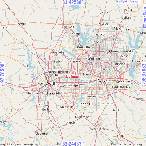
Euless GPS coordinates[2]
32° 50' 13.452" North, 97° 4' 55.02" West
| Map corner | latitude | longitude |
|---|---|---|
| Upper-left | 33.42588°, | -97.78508° |
| Center: | 32.83707°, | -97.08195° |
| Lower-right: | 32.24433°, | -96.37883° |
| Map W x H: | 131.4×131.4 km | = 81.6×81.6mi |
| max Lat: | 71.29058° ⇑85.8% North |
| Euless: | 32.83707° |
| min Lat: | ⇓14.2% South 19.06759° |
| min Long | Euless | max Long |
| -171.73463° | -97.08195° | -66.98998° |
| W 24.1%⇐ | ⇒75.9% E |
Elevation
Elevation of Euless is 184 m = 604 ft, and this is 110.8 m = 364 ft below average elevation for this country.
| Max E: |
3189 m = 10463 ft | 53.9% |
| Avg. | 294.8 m = 967 ft | |
| Euless | 184 m = 604 ft | |
Min E: |
-60 m = -197 ft | 46.1% |
See also: Euless elevation on elevation.city.
Geographical zone
Euless is located in North temperate zone (between Tropic of Cancer and the Arctic Circle). Distance of this Northern Tropic circle is 1045.2 km =649.5 mi to South.| Distance of | km | miles | from Euless |
|---|---|---|---|
| North Pole | 6355.9 | 3949.4 | to North |
| Arctic Circle | 3750 | 2330.1 | to North |
| Tropic Cancer | 1045.2 | 649.5 | to South |
| Equator | 3651.1 | 2268.7 | to South |


Nearby cities:
15 places around Euless: (largest is in red/bold)
• Arlington
11.5 km =7.1 mi,  192°
192°
• Bedford
5.8 km =3.6 mi,  277°
277°
• Colleyville
8.4 km =5.2 mi,  305°
305°
• Coppell
14.5 km =9 mi,  25°
25°
• Dalworthington Gardens
16.4 km =10.2 mi,  204°
204°
• Grand Prairie
12.8 km =8 mi,  142°
142°
• Grapevine
10.8 km =6.7 mi,  1°
1°
• Haltom City
18 km =11.2 mi,  256°
256°
• Hurst
8.4 km =5.2 mi, 259°
• Irving
12.7 km =7.9 mi,  101°
101°
• North Richland Hills
13.7 km =8.5 mi,  268°
268°
• Pantego
15.3 km =9.5 mi,  207°
207°
• Richland Hills
13.9 km =8.6 mi, 260°
• Southlake
12.6 km =7.8 mi,  337°
337°
• Watauga
16.3 km =10.1 mi, 278°
Sources, notices
• [Note1] Compared only with cities in United States existing in our database
• [Src1] Map data: © OpenStreetMap contributors (CC-BY-SA)
• [Src2] Other city data from geonames.org with taken over terms of usage.
• [Src3] Geographical zone / Annual Mean Temperature by Robert A. Rohde @ Wikipedia
