Hackberry geodata
Hackberry (Texas) is a populated place; located in United States in America/Chicago (GMT-5) time zone. With population of 504 people, there are 20845 cities with bigger population in this country. Compared to other cities in United States, 94.4% of cities are located further ↑North; 75.4% of cities are located further →East and 72.5% of cities have higher elevation than Hackberry. Note1


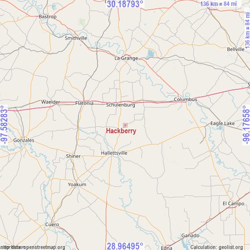
Hackberry GPS coordinates[2]
29° 34' 41.844" North, 96° 52' 46.92" West
| Map corner | latitude | longitude |
|---|---|---|
| Upper-left | 30.18793°, | -97.58283° |
| Center: | 29.57829°, | -96.8797° |
| Lower-right: | 28.96495°, | -96.17658° |
| Map W x H: | 136×136 km | = 84.5×84.5mi |
| max Lat: | 71.29058° ⇑94.4% North |
| Hackberry: | 29.57829° |
| min Lat: | ⇓5.6% South 19.06759° |
| min Long | Hackberry | max Long |
| -171.73463° | -96.8797° | -66.98998° |
| W 24.6%⇐ | ⇒75.4% E |
Elevation
Elevation of Hackberry is 86 m = 282 ft, and this is 208.8 m = 685 ft below average elevation for this country.
| Max E: |
3189 m = 10463 ft | 72.5% |
| Avg. | 294.8 m = 967 ft | |
| Hackberry | 86 m = 282 ft | |
Min E: |
-60 m = -197 ft | 27.5% |
See also: United States elevation on elevation.city.
Geographical zone
Hackberry is located in North temperate zone (between Tropic of Cancer and the Arctic Circle). Distance of this Northern Tropic circle is 682.9 km =424.3 mi to South.| Distance of | km | miles | from Hackberry |
|---|---|---|---|
| North Pole | 6718.3 | 4174.6 | to North |
| Arctic Circle | 4112.4 | 2555.3 | to North |
| Tropic Cancer | 682.9 | 424.3 | to South |
| Equator | 3288.8 | 2043.6 | to South |


Nearby cities:
15 places around Hackberry: (largest is in red/bold)
• Columbus
35.8 km =22.2 mi,  66°
66°
• Cuero
66.9 km =41.6 mi,  216°
216°
• Eagle Lake
52.8 km =32.8 mi,  88°
88°
• Flatonia
25.2 km =15.7 mi,  298°
298°
• Glidden
31.5 km =19.6 mi,  64°
64°
• Gonzales
56.1 km =34.9 mi,  261°
261°
• Hallettsville
16.1 km =10 mi,  201°
201°
• La Grange
36.4 km =22.6 mi,  0°
0°
• Moulton
25.4 km =15.8 mi,  269°
269°
• Schulenburg
11.7 km =7.3 mi,  348°
348°
• Shiner
32.7 km =20.3 mi,  239°
239°
• Smithville
54.9 km =34.1 mi,  330°
330°
• Waelder
42.5 km =26.4 mi,  287°
287°
• Weimar
16.9 km =10.5 mi,  34°
34°
• Yoakum
41.7 km =25.9 mi, 219°
Sources, notices
• [Note1] Compared only with cities in United States existing in our database
• [Src1] Map data: © OpenStreetMap contributors (CC-BY-SA)
• [Src2] Other city data from geonames.org with taken over terms of usage.
• [Src3] Geographical zone / Annual Mean Temperature by Robert A. Rohde @ Wikipedia
