Shiner geodata
Shiner (Texas) is a populated place; located in United States in America/Chicago (GMT-5) time zone. With population of 2,139 people, there are 11499 cities with bigger population in this country. Compared to other cities in United States, 94.7% of cities are located further ↑North; 76.2% of cities are located further →East and 67.9% of cities have higher elevation than Shiner. Note1


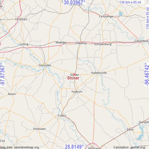
Shiner GPS coordinates[2]
29° 25' 44.868" North, 97° 10' 13.944" West
| Map corner | latitude | longitude |
|---|---|---|
| Upper-left | 30.03967°, | -97.87367° |
| Center: | 29.42913°, | -97.17054° |
| Lower-right: | 28.8149°, | -96.46742° |
| Map W x H: | 136.2×136.2 km | = 84.6×84.6mi |
| max Lat: | 71.29058° ⇑94.7% North |
| Shiner: | 29.42913° |
| min Lat: | ⇓5.3% South 19.06759° |
| min Long | Shiner | max Long |
| -171.73463° | -97.17054° | -66.98998° |
| W 23.8%⇐ | ⇒76.2% E |
Elevation
Elevation of Shiner is 113 m = 371 ft, and this is 181.8 m = 596 ft below average elevation for this country.
| Max E: |
3189 m = 10463 ft | 67.9% |
| Avg. | 294.8 m = 967 ft | |
| Shiner | 113 m = 371 ft | |
Min E: |
-60 m = -197 ft | 32.1% |
See also: United States elevation on elevation.city.
Geographical zone
Shiner is located in North temperate zone (between Tropic of Cancer and the Arctic Circle). Distance of this Northern Tropic circle is 666.3 km =414 mi to South.| Distance of | km | miles | from Shiner |
|---|---|---|---|
| North Pole | 6734.8 | 4184.8 | to North |
| Arctic Circle | 4129 | 2565.6 | to North |
| Tropic Cancer | 666.3 | 414 | to South |
| Equator | 3272.2 | 2033.3 | to South |


Nearby cities:
15 places around Shiner: (largest is in red/bold)
• Cuero
39 km =24.2 mi,  197°
197°
• Flatonia
29.4 km =18.3 mi,  11°
11°
• Gonzales
28.5 km =17.7 mi,  286°
286°
• Hackberry
32.7 km =20.3 mi,  59°
59°
• Hallettsville
22.3 km =13.9 mi,  85°
85°
• La Grange
60.1 km =37.3 mi,  28°
28°
• Luling
53.9 km =33.5 mi,  301°
301°
• Moulton
16.4 km =10.2 mi, 9°
• Nixon
60.3 km =37.5 mi,  252°
252°
• Schulenburg
38.2 km =23.7 mi,  42°
42°
• Smiley
48.5 km =30.1 mi, 248°
• Waelder
32.1 km =19.9 mi,  337°
337°
• Weimar
48.5 km =30.1 mi,  51°
51°
• Yoakum
15.8 km =9.8 mi,  173°
173°
• Yorktown
59.3 km =36.8 mi,  212°
212°
Sources, notices
• [Note1] Compared only with cities in United States existing in our database
• [Src1] Map data: © OpenStreetMap contributors (CC-BY-SA)
• [Src2] Other city data from geonames.org with taken over terms of usage.
• [Src3] Geographical zone / Annual Mean Temperature by Robert A. Rohde @ Wikipedia
