Yoakum geodata
Yoakum (Texas) is a populated place; located in United States in America/Chicago (GMT-5) time zone. With population of 6,016 people, there are 6393 cities with bigger population in this country. Compared to other cities in United States, 95% of cities are located further ↑North; 76.2% of cities are located further →East and 70% of cities have higher elevation than Yoakum. Note1


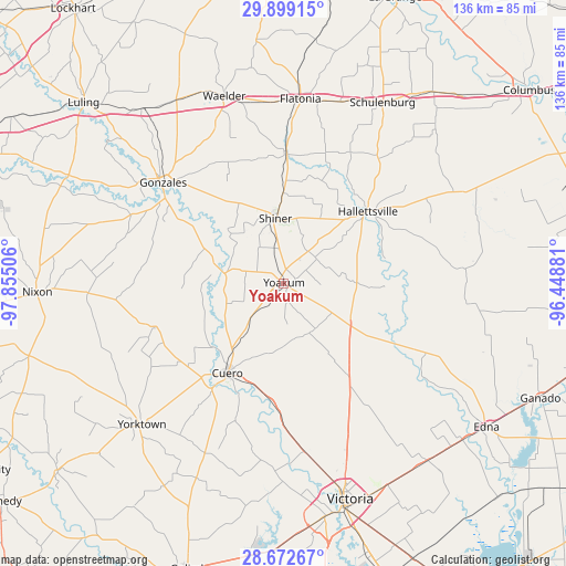
Yoakum GPS coordinates[2]
29° 17' 15.9" North, 97° 9' 6.948" West
| Map corner | latitude | longitude |
|---|---|---|
| Upper-left | 29.89915°, | -97.85506° |
| Center: | 29.28775°, | -97.15193° |
| Lower-right: | 28.67267°, | -96.44881° |
| Map W x H: | 136.4×136.4 km | = 84.8×84.8mi |
| max Lat: | 71.29058° ⇑95% North |
| Yoakum: | 29.28775° |
| min Lat: | ⇓5% South 19.06759° |
| min Long | Yoakum | max Long |
| -171.73463° | -97.15193° | -66.98998° |
| W 23.8%⇐ | ⇒76.2% E |
Elevation
Elevation of Yoakum is 101 m = 331 ft, and this is 193.8 m = 636 ft below average elevation for this country.
| Max E: |
3189 m = 10463 ft | 70% |
| Avg. | 294.8 m = 967 ft | |
| Yoakum | 101 m = 331 ft | |
Min E: |
-60 m = -197 ft | 30% |
See also: United States elevation on elevation.city.
Geographical zone
Yoakum is located in North temperate zone (between Tropic of Cancer and the Arctic Circle). Distance of this Northern Tropic circle is 650.6 km =404.3 mi to South.| Distance of | km | miles | from Yoakum |
|---|---|---|---|
| North Pole | 6750.6 | 4194.6 | to North |
| Arctic Circle | 4144.7 | 2575.4 | to North |
| Tropic Cancer | 650.6 | 404.3 | to South |
| Equator | 3256.5 | 2023.5 | to South |


Nearby cities:
15 places around Yoakum: (largest is in red/bold)
• Cuero
25.3 km =15.7 mi,  211°
211°
• Flatonia
44.7 km =27.8 mi,  5°
5°
• Gonzales
37.6 km =23.4 mi,  309°
309°
• Hackberry
41.7 km =25.9 mi,  39°
39°
• Hallettsville
26.8 km =16.7 mi,  49°
49°
• Inez
55.4 km =34.4 mi,  140°
140°
• Moulton
31.9 km =19.8 mi,  1°
1°
• Quail Creek
57.3 km =35.6 mi,  173°
173°
• Schulenburg
50 km =31.1 mi,  28°
28°
• Shiner
15.8 km =9.8 mi,  353°
353°
• Smiley
47 km =29.2 mi,  267°
267°
• Victoria
55.6 km =34.5 mi,  164°
164°
• Waelder
47.5 km =29.5 mi,  342°
342°
• Weimar
58.5 km =36.4 mi, 37°
• Yorktown
48.2 km =30 mi,  224°
224°
Sources, notices
• [Note1] Compared only with cities in United States existing in our database
• [Src1] Map data: © OpenStreetMap contributors (CC-BY-SA)
• [Src2] Other city data from geonames.org with taken over terms of usage.
• [Src3] Geographical zone / Annual Mean Temperature by Robert A. Rohde @ Wikipedia
