Hilltop Lakes geodata
Hilltop Lakes (Texas) is a populated place; located in United States in America/Chicago (GMT-5) time zone. With population of 1,101 people, there are 15667 cities with bigger population in this country. Compared to other cities in United States, 90.6% of cities are located further ↑North; 73.9% of cities are located further →East and 61.7% of cities have higher elevation than Hilltop Lakes. Note1


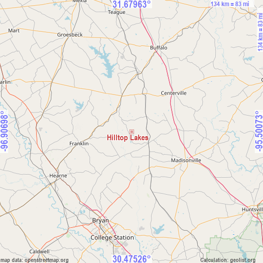
Hilltop Lakes GPS coordinates[2]
31° 4' 45.66" North, 96° 12' 13.86" West
| Map corner | latitude | longitude |
|---|---|---|
| Upper-left | 31.67963°, | -96.90698° |
| Center: | 31.07935°, | -96.20385° |
| Lower-right: | 30.47526°, | -95.50073° |
| Map W x H: | 133.9×133.9 km | = 83.2×83.2mi |
| max Lat: | 71.29058° ⇑90.6% North |
| Hilltop Lakes: | 31.07935° |
| min Lat: | ⇓9.4% South 19.06759° |
| min Long | Hilltop Lakes | max Long |
| -171.73463° | -96.20385° | -66.98998° |
| W 26.1%⇐ | ⇒73.9% E |
Elevation
Elevation of Hilltop Lakes is 146 m = 479 ft, and this is 148.8 m = 488 ft below average elevation for this country.
| Max E: |
3189 m = 10463 ft | 61.7% |
| Avg. | 294.8 m = 967 ft | |
| Hilltop Lakes | 146 m = 479 ft | |
Min E: |
-60 m = -197 ft | 38.3% |
See also: United States elevation on elevation.city.
Geographical zone
Hilltop Lakes is located in North temperate zone (between Tropic of Cancer and the Arctic Circle). Distance of this Northern Tropic circle is 849.8 km =528 mi to South.| Distance of | km | miles | from Hilltop Lakes |
|---|---|---|---|
| North Pole | 6551.4 | 4070.8 | to North |
| Arctic Circle | 3945.5 | 2451.6 | to North |
| Tropic Cancer | 849.8 | 528 | to South |
| Equator | 3455.7 | 2147.3 | to South |


Nearby cities:
15 places around Hilltop Lakes: (largest is in red/bold)
• Blue Ridge
55.6 km =34.5 mi,  293°
293°
• Bremond
46 km =28.6 mi,  281°
281°
• Bryan
47.7 km =29.6 mi,  199°
199°
• Buffalo
44.9 km =27.9 mi,  17°
17°
• Calvert
46.2 km =28.7 mi,  255°
255°
• Center
52.4 km =32.6 mi,  336°
336°
• Centerville
29.2 km =18.1 mi,  47°
47°
• College Station
51.7 km =32.1 mi,  193°
193°
• Franklin
27.5 km =17.1 mi, 257°
• Groesbeck
58.6 km =36.4 mi,  327°
327°
• Hearne
43.3 km =26.9 mi,  238°
238°
• Jewett
31.9 km =19.8 mi,  10°
10°
• Madisonville
31.3 km =19.4 mi,  117°
117°
• Normangee
10.1 km =6.3 mi, 123°
• Thornton
50.9 km =31.6 mi,  316°
316°
Sources, notices
• [Note1] Compared only with cities in United States existing in our database
• [Src1] Map data: © OpenStreetMap contributors (CC-BY-SA)
• [Src2] Other city data from geonames.org with taken over terms of usage.
• [Src3] Geographical zone / Annual Mean Temperature by Robert A. Rohde @ Wikipedia
