Calvert geodata
Calvert (Texas) is a populated place; located in United States in America/Chicago (GMT-5) time zone. With population of 1,151 people, there are 15379 cities with bigger population in this country. Compared to other cities in United States, 90.8% of cities are located further ↑North; 74.9% of cities are located further →East and 69.4% of cities have higher elevation than Calvert. Note1


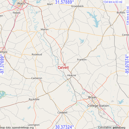
Calvert GPS coordinates[2]
30° 58' 40.692" North, 96° 40' 25.896" West
| Map corner | latitude | longitude |
|---|---|---|
| Upper-left | 31.57889°, | -97.37699° |
| Center: | 30.97797°, | -96.67386° |
| Lower-right: | 30.37324°, | -95.97074° |
| Map W x H: | 134.1×134.1 km | = 83.3×83.3mi |
| max Lat: | 71.29058° ⇑90.8% North |
| Calvert: | 30.97797° |
| min Lat: | ⇓9.2% South 19.06759° |
| min Long | Calvert | max Long |
| -171.73463° | -96.67386° | -66.98998° |
| W 25.1%⇐ | ⇒74.9% E |
Elevation
Elevation of Calvert is 104 m = 341 ft, and this is 190.8 m = 626 ft below average elevation for this country.
| Max E: |
3189 m = 10463 ft | 69.4% |
| Avg. | 294.8 m = 967 ft | |
| Calvert | 104 m = 341 ft | |
Min E: |
-60 m = -197 ft | 30.6% |
See also: United States elevation on elevation.city.
Geographical zone
Calvert is located in North temperate zone (between Tropic of Cancer and the Arctic Circle). Distance of this Northern Tropic circle is 838.5 km =521 mi to South.| Distance of | km | miles | from Calvert |
|---|---|---|---|
| North Pole | 6562.6 | 4077.8 | to North |
| Arctic Circle | 3956.7 | 2458.6 | to North |
| Tropic Cancer | 838.5 | 521 | to South |
| Equator | 3444.4 | 2140.3 | to South |


Nearby cities:
15 places around Calvert: (largest is in red/bold)
• Blue Ridge
33.8 km =21 mi,  349°
349°
• Bremond
20.8 km =12.9 mi,  359°
359°
• Bryan
44.5 km =27.7 mi,  139°
139°
• Buckholts
44.6 km =27.7 mi,  254°
254°
• Caldwell
49.7 km =30.9 mi,  182°
182°
• Cameron
32.1 km =19.9 mi,  244°
244°
• Chilton
50.1 km =31.1 mi,  312°
312°
• Franklin
18.8 km =11.7 mi,  73°
73°
• Hearne
13.5 km =8.4 mi,  145°
145°
• Hilltop Lakes
46.2 km =28.7 mi,  75°
75°
• Lott
42.7 km =26.5 mi, 305°
• Marlin
42.3 km =26.3 mi,  329°
329°
• Rockdale
47.6 km =29.6 mi,  221°
221°
• Rosebud
30.9 km =19.2 mi,  289°
289°
• Thornton
49.1 km =30.5 mi,  11°
11°
Sources, notices
• [Note1] Compared only with cities in United States existing in our database
• [Src1] Map data: © OpenStreetMap contributors (CC-BY-SA)
• [Src2] Other city data from geonames.org with taken over terms of usage.
• [Src3] Geographical zone / Annual Mean Temperature by Robert A. Rohde @ Wikipedia
