College Station geodata
College Station (Texas) is a populated place; located in United States in America/Chicago (GMT-5) time zone. With population of 107,889 people, there are 316 cities with bigger population in this country. Compared to other cities in United States, 91.4% of cities are located further ↑North; 74.1% of cities are located further →East and 68.9% of cities have higher elevation than College Station. Note1


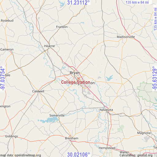
College Station GPS coordinates[2]
30° 37' 40.728" North, 96° 20' 3.876" West
| Map corner | latitude | longitude |
|---|---|---|
| Upper-left | 31.23112°, | -97.03754° |
| Center: | 30.62798°, | -96.33441° |
| Lower-right: | 30.02106°, | -95.63129° |
| Map W x H: | 134.5×134.5 km | = 83.6×83.6mi |
| max Lat: | 71.29058° ⇑91.4% North |
| College Station: | 30.62798° |
| min Lat: | ⇓8.6% South 19.06759° |
| min Long | College Station | max Long |
| -171.73463° | -96.33441° | -66.98998° |
| W 25.9%⇐ | ⇒74.1% E |
Elevation
Elevation of College Station is 107 m = 351 ft, and this is 187.8 m = 616 ft below average elevation for this country.
| Max E: |
3189 m = 10463 ft | 68.9% |
| Avg. | 294.8 m = 967 ft | |
| College Station | 107 m = 351 ft | |
Min E: |
-60 m = -197 ft | 31.1% |
See also: College Station elevation on elevation.city.
Geographical zone
College Station is located in North temperate zone (between Tropic of Cancer and the Arctic Circle). Distance of this Northern Tropic circle is 799.6 km =496.8 mi to South.| Distance of | km | miles | from College Station |
|---|---|---|---|
| North Pole | 6601.5 | 4102 | to North |
| Arctic Circle | 3995.7 | 2482.8 | to North |
| Tropic Cancer | 799.6 | 496.8 | to South |
| Equator | 3405.5 | 2116.1 | to South |


Nearby cities:
15 places around College Station: (largest is in red/bold)
• Anderson
36.8 km =22.9 mi,  115°
115°
• Brenham
51.6 km =32.1 mi,  186°
186°
• Bryan
6.2 km =3.9 mi,  326°
326°
• Caldwell
36 km =22.4 mi,  252°
252°
• Calvert
50.6 km =31.4 mi,  320°
320°
• Franklin
46.5 km =28.9 mi,  341°
341°
• Hearne
37.2 km =23.1 mi, 318°
• Hempstead
63.9 km =39.7 mi,  157°
157°
• Hilltop Lakes
51.7 km =32.1 mi,  13°
13°
• Madisonville
54 km =33.6 mi,  48°
48°
• Navasota
35.6 km =22.1 mi,  138°
138°
• Normangee
49.3 km =30.6 mi,  25°
25°
• Rockdale
63.9 km =39.7 mi,  272°
272°
• Snook
19.9 km =12.4 mi,  219°
219°
• Somerville
36.4 km =22.6 mi,  210°
210°
Sources, notices
• [Note1] Compared only with cities in United States existing in our database
• [Src1] Map data: © OpenStreetMap contributors (CC-BY-SA)
• [Src2] Other city data from geonames.org with taken over terms of usage.
• [Src3] Geographical zone / Annual Mean Temperature by Robert A. Rohde @ Wikipedia
