Bryan geodata
Bryan (Texas) is a seat of a second-order administrative division; located in United States in America/Chicago (GMT-5) time zone. With population of 82,118 people, there are 477 cities with bigger population in this country. Compared to other cities in United States, 91.3% of cities are located further ↑North; 74.2% of cities are located further →East and 67.3% of cities have higher elevation than Bryan. Note1


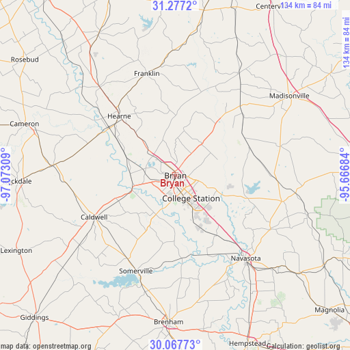
Bryan GPS coordinates[2]
30° 40' 27.696" North, 96° 22' 11.856" West
| Map corner | latitude | longitude |
|---|---|---|
| Upper-left | 31.2772°, | -97.07309° |
| Center: | 30.67436°, | -96.36996° |
| Lower-right: | 30.06773°, | -95.66684° |
| Map W x H: | 134.5×134.5 km | = 83.6×83.6mi |
| max Lat: | 71.29058° ⇑91.3% North |
| Bryan: | 30.67436° |
| min Lat: | ⇓8.7% South 19.06759° |
| min Long | Bryan | max Long |
| -171.73463° | -96.36996° | -66.98998° |
| W 25.8%⇐ | ⇒74.2% E |
Elevation
Elevation of Bryan is 116 m = 381 ft, and this is 178.8 m = 587 ft below average elevation for this country.
| Max E: |
3189 m = 10463 ft | 67.3% |
| Avg. | 294.8 m = 967 ft | |
| Bryan | 116 m = 381 ft | |
Min E: |
-60 m = -197 ft | 32.7% |
See also: Bryan elevation on elevation.city.
Geographical zone
Bryan is located in North temperate zone (between Tropic of Cancer and the Arctic Circle). Distance of this Northern Tropic circle is 804.8 km =500.1 mi to South.| Distance of | km | miles | from Bryan |
|---|---|---|---|
| North Pole | 6596.4 | 4098.8 | to North |
| Arctic Circle | 3990.5 | 2479.6 | to North |
| Tropic Cancer | 804.8 | 500.1 | to South |
| Equator | 3410.7 | 2119.3 | to South |


Nearby cities:
15 places around Bryan: (largest is in red/bold)
• Anderson
42.2 km =26.2 mi,  119°
119°
• Brenham
56.5 km =35.1 mi,  182°
182°
• Caldwell
34.8 km =21.6 mi,  242°
242°
• Calvert
44.5 km =27.7 mi,  319°
319°
• Cameron
61.3 km =38.1 mi,  288°
288°
• College Station
6.2 km =3.9 mi,  146°
146°
• Franklin
40.6 km =25.2 mi,  344°
344°
• Hearne
31.1 km =19.3 mi, 316°
• Hilltop Lakes
47.7 km =29.6 mi,  19°
19°
• Madisonville
53.4 km =33.2 mi,  55°
55°
• Navasota
41.8 km =26 mi,  139°
139°
• Normangee
46.4 km =28.8 mi,  31°
31°
• Rockdale
60.4 km =37.5 mi,  268°
268°
• Snook
22.5 km =14 mi,  203°
203°
• Somerville
39.5 km =24.5 mi, 202°
Sources, notices
• [Note1] Compared only with cities in United States existing in our database
• [Src1] Map data: © OpenStreetMap contributors (CC-BY-SA)
• [Src2] Other city data from geonames.org with taken over terms of usage.
• [Src3] Geographical zone / Annual Mean Temperature by Robert A. Rohde @ Wikipedia
