Hondo geodata
Hondo (Texas) is a seat of a second-order administrative division; located in United States in America/Chicago (GMT-5) time zone. With population of 9,119 people, there are 4758 cities with bigger population in this country. Compared to other cities in United States, 94.9% of cities are located further ↑North; 80% of cities are located further →East and 67.6% of cities have lower elevation than Hondo. Note1


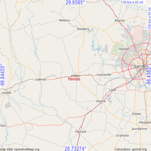
Hondo GPS coordinates[2]
29° 20' 50.856" North, 99° 8' 29.112" West
| Map corner | latitude | longitude |
|---|---|---|
| Upper-left | 29.9585°, | -99.84455° |
| Center: | 29.34746°, | -99.14142° |
| Lower-right: | 28.73274°, | -98.4383° |
| Map W x H: | 136.3×136.3 km | = 84.7×84.7mi |
| max Lat: | 71.29058° ⇑94.9% North |
| Hondo: | 29.34746° |
| min Lat: | ⇓5.1% South 19.06759° |
| min Long | Hondo | max Long |
| -171.73463° | -99.14142° | -66.98998° |
| W 20%⇐ | ⇒80% E |
Elevation
Elevation of Hondo is 274 m = 899 ft, and this is 20.8 m = 68 ft below average elevation for this country.
| Max E: |
3189 m = 10463 ft | 32.4% |
| Avg. | 294.8 m = 967 ft | |
| Hondo | 274 m = 899 ft | |
Min E: |
-60 m = -197 ft | 67.6% |
See also: United States elevation on elevation.city.
Geographical zone
Hondo is located in North temperate zone (between Tropic of Cancer and the Arctic Circle). Distance of this Northern Tropic circle is 657.2 km =408.4 mi to South.| Distance of | km | miles | from Hondo |
|---|---|---|---|
| North Pole | 6743.9 | 4190.5 | to North |
| Arctic Circle | 4138 | 2571.2 | to North |
| Tropic Cancer | 657.2 | 408.4 | to South |
| Equator | 3263.1 | 2027.6 | to South |


Nearby cities:
15 places around Hondo: (largest is in red/bold)
• Bandera
42.7 km =26.5 mi,  8°
8°
• Castroville
25.5 km =15.8 mi,  87°
87°
• D'Hanis
13.5 km =8.4 mi,  261°
261°
• Devine
32.5 km =20.2 mi,  135°
135°
• Helotes
50.7 km =31.5 mi,  59°
59°
• Knippa
48.4 km =30.1 mi, 263°
• La Coste
32.4 km =20.1 mi,  97°
97°
• Lakehills
34.4 km =21.4 mi,  33°
33°
• Lytle
35.8 km =22.2 mi,  110°
110°
• Macdona
43.7 km =27.2 mi, 93°
• Natalia
32.2 km =20 mi,  122°
122°
• North Pearsall
48.3 km =30 mi,  174°
174°
• Sabinal
31.7 km =19.7 mi, 263°
• Somerset
48.8 km =30.3 mi, 106°
• Von Ormy
48.6 km =30.2 mi, 97°
Sources, notices
• [Note1] Compared only with cities in United States existing in our database
• [Src1] Map data: © OpenStreetMap contributors (CC-BY-SA)
• [Src2] Other city data from geonames.org with taken over terms of usage.
• [Src3] Geographical zone / Annual Mean Temperature by Robert A. Rohde @ Wikipedia
