Castroville geodata
Castroville (Texas) is a populated place; located in United States in America/Chicago (GMT-5) time zone. With population of 2,931 people, there are 9749 cities with bigger population in this country. Compared to other cities in United States, 94.9% of cities are located further ↑North; 79.8% of cities are located further →East and 58.8% of cities have lower elevation than Castroville. Note1


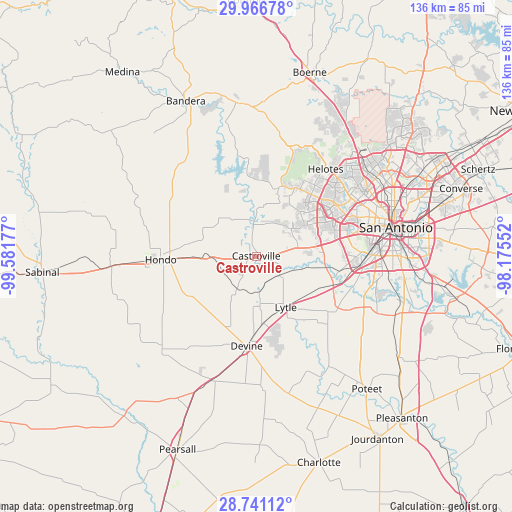
Castroville GPS coordinates[2]
29° 21' 20.844" North, 98° 52' 43.104" West
| Map corner | latitude | longitude |
|---|---|---|
| Upper-left | 29.96678°, | -99.58177° |
| Center: | 29.35579°, | -98.87864° |
| Lower-right: | 28.74112°, | -98.17552° |
| Map W x H: | 136.3×136.3 km | = 84.7×84.7mi |
| max Lat: | 71.29058° ⇑94.9% North |
| Castroville: | 29.35579° |
| min Lat: | ⇓5.1% South 19.06759° |
| min Long | Castroville | max Long |
| -171.73463° | -98.87864° | -66.98998° |
| W 20.2%⇐ | ⇒79.8% E |
Elevation
Elevation of Castroville is 234 m = 768 ft, and this is 60.8 m = 199 ft below average elevation for this country.
| Max E: |
3189 m = 10463 ft | 41.2% |
| Avg. | 294.8 m = 967 ft | |
| Castroville | 234 m = 768 ft | |
Min E: |
-60 m = -197 ft | 58.8% |
See also: United States elevation on elevation.city.
Geographical zone
Castroville is located in North temperate zone (between Tropic of Cancer and the Arctic Circle). Distance of this Northern Tropic circle is 658.1 km =408.9 mi to South.| Distance of | km | miles | from Castroville |
|---|---|---|---|
| North Pole | 6743 | 4189.9 | to North |
| Arctic Circle | 4137.1 | 2570.7 | to North |
| Tropic Cancer | 658.1 | 408.9 | to South |
| Equator | 3264.1 | 2028.2 | to South |


Nearby cities:
15 places around Castroville: (largest is in red/bold)
• Balcones Heights
34.9 km =21.7 mi,  65°
65°
• Devine
24.1 km =15 mi,  186°
186°
• Grey Forest
34.6 km =21.5 mi,  33°
33°
• Helotes
30.7 km =19.1 mi,  36°
36°
• Hondo
25.5 km =15.8 mi,  267°
267°
• La Coste
8.3 km =5.2 mi,  126°
126°
• Lackland Air Force Base
25.5 km =15.8 mi,  82°
82°
• Lakehills
28.4 km =17.6 mi,  347°
347°
• Leon Valley
29.6 km =18.4 mi,  58°
58°
• Lytle
15.8 km =9.8 mi,  149°
149°
• Macdona
18.5 km =11.5 mi,  100°
100°
• Natalia
18.5 km =11.5 mi,  175°
175°
• San Antonio
38.1 km =23.7 mi, 78°
• Somerset
25.8 km =16 mi,  123°
123°
• Von Ormy
23.9 km =14.9 mi,  108°
108°
Sources, notices
• [Note1] Compared only with cities in United States existing in our database
• [Src1] Map data: © OpenStreetMap contributors (CC-BY-SA)
• [Src2] Other city data from geonames.org with taken over terms of usage.
• [Src3] Geographical zone / Annual Mean Temperature by Robert A. Rohde @ Wikipedia
