Devine geodata
Devine (Texas) is a populated place; located in United States in America/Chicago (GMT-5) time zone. With population of 4,705 people, there are 7437 cities with bigger population in this country. Compared to other cities in United States, 95.1% of cities are located further ↑North; 79.8% of cities are located further →East and 50.5% of cities have lower elevation than Devine. Note1


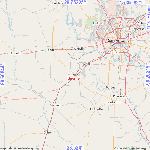
Devine GPS coordinates[2]
29° 8' 23.856" North, 98° 54' 19.116" West
| Map corner | latitude | longitude |
|---|---|---|
| Upper-left | 29.75225°, | -99.60844° |
| Center: | 29.13996°, | -98.90531° |
| Lower-right: | 28.524°, | -98.20219° |
| Map W x H: | 136.6×136.6 km | = 84.9×84.9mi |
| max Lat: | 71.29058° ⇑95.1% North |
| Devine: | 29.13996° |
| min Lat: | ⇓4.9% South 19.06759° |
| min Long | Devine | max Long |
| -171.73463° | -98.90531° | -66.98998° |
| W 20.2%⇐ | ⇒79.8% E |
Elevation
Elevation of Devine is 200 m = 656 ft, and this is 94.8 m = 311 ft below average elevation for this country.
| Max E: |
3189 m = 10463 ft | 49.5% |
| Avg. | 294.8 m = 967 ft | |
| Devine | 200 m = 656 ft | |
Min E: |
-60 m = -197 ft | 50.5% |
See also: United States elevation on elevation.city.
Geographical zone
Devine is located in North temperate zone (between Tropic of Cancer and the Arctic Circle). Distance of this Northern Tropic circle is 634.1 km =394 mi to South.| Distance of | km | miles | from Devine |
|---|---|---|---|
| North Pole | 6767 | 4204.8 | to North |
| Arctic Circle | 4161.1 | 2585.6 | to North |
| Tropic Cancer | 634.1 | 394 | to South |
| Equator | 3240.1 | 2013.3 | to South |


Nearby cities:
15 places around Devine: (largest is in red/bold)
• Castroville
24.1 km =15 mi,  6°
6°
• Charlotte
36.5 km =22.7 mi,  147°
147°
• D'Hanis
42.1 km =26.2 mi,  300°
300°
• Hondo
32.5 km =20.2 mi,  315°
315°
• La Coste
21.1 km =13.1 mi,  25°
25°
• Lackland Air Force Base
39.1 km =24.3 mi,  45°
45°
• Leming
41.6 km =25.8 mi,  100°
100°
• Lytle
14.8 km =9.2 mi, 45°
• Macdona
29.3 km =18.2 mi, 45°
• Natalia
6.9 km =4.3 mi,  36°
36°
• North Pearsall
31.2 km =19.4 mi,  216°
216°
• Pearsall
33.2 km =20.6 mi,  213°
213°
• Poteet
34.6 km =21.5 mi,  108°
108°
• Somerset
25.9 km =16.1 mi,  68°
68°
• Von Ormy
30.3 km =18.8 mi,  56°
56°
Sources, notices
• [Note1] Compared only with cities in United States existing in our database
• [Src1] Map data: © OpenStreetMap contributors (CC-BY-SA)
• [Src2] Other city data from geonames.org with taken over terms of usage.
• [Src3] Geographical zone / Annual Mean Temperature by Robert A. Rohde @ Wikipedia
