La Coste geodata
La Coste (Texas) is a populated place; located in United States in America/Chicago (GMT-5) time zone. With population of 1,119 people, there are 15571 cities with bigger population in this country. Compared to other cities in United States, 94.9% of cities are located further ↑North; 79.8% of cities are located further →East and 55.8% of cities have lower elevation than La Coste. Note1


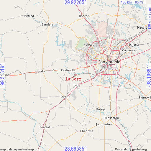
La Coste GPS coordinates[2]
29° 18' 38.844" North, 98° 48' 36.108" West
| Map corner | latitude | longitude |
|---|---|---|
| Upper-left | 29.92205°, | -99.51316° |
| Center: | 29.31079°, | -98.81003° |
| Lower-right: | 28.69585°, | -98.10691° |
| Map W x H: | 136.3×136.3 km | = 84.7×84.7mi |
| max Lat: | 71.29058° ⇑94.9% North |
| La Coste: | 29.31079° |
| min Lat: | ⇓5.1% South 19.06759° |
| min Long | La Coste | max Long |
| -171.73463° | -98.81003° | -66.98998° |
| W 20.2%⇐ | ⇒79.8% E |
Elevation
Elevation of La Coste is 222 m = 728 ft, and this is 72.8 m = 239 ft below average elevation for this country.
| Max E: |
3189 m = 10463 ft | 44.2% |
| Avg. | 294.8 m = 967 ft | |
| La Coste | 222 m = 728 ft | |
Min E: |
-60 m = -197 ft | 55.8% |
See also: United States elevation on elevation.city.
Geographical zone
La Coste is located in North temperate zone (between Tropic of Cancer and the Arctic Circle). Distance of this Northern Tropic circle is 653.1 km =405.8 mi to South.| Distance of | km | miles | from La Coste |
|---|---|---|---|
| North Pole | 6748 | 4193 | to North |
| Arctic Circle | 4142.1 | 2573.8 | to North |
| Tropic Cancer | 653.1 | 405.8 | to South |
| Equator | 3259.1 | 2025.1 | to South |


Nearby cities:
15 places around La Coste: (largest is in red/bold)
• Balcones Heights
31.9 km =19.8 mi,  51°
51°
• Castroville
8.3 km =5.2 mi,  306°
306°
• Devine
21.1 km =13.1 mi,  205°
205°
• Grey Forest
36.1 km =22.4 mi,  20°
20°
• Helotes
31.9 km =19.8 mi, 21°
• Hondo
32.4 km =20.1 mi,  277°
277°
• Lackland Air Force Base
20.4 km =12.7 mi,  65°
65°
• Lakehills
35.1 km =21.8 mi,  338°
338°
• Leon Valley
27.6 km =17.1 mi,  42°
42°
• Lytle
8.7 km =5.4 mi,  171°
171°
• Macdona
11.6 km =7.2 mi,  81°
81°
• Natalia
14.4 km =8.9 mi,  200°
200°
• San Antonio
33.1 km =20.6 mi, 67°
• Somerset
17.5 km =10.9 mi,  122°
122°
• Von Ormy
16.2 km =10.1 mi,  98°
98°
Sources, notices
• [Note1] Compared only with cities in United States existing in our database
• [Src1] Map data: © OpenStreetMap contributors (CC-BY-SA)
• [Src2] Other city data from geonames.org with taken over terms of usage.
• [Src3] Geographical zone / Annual Mean Temperature by Robert A. Rohde @ Wikipedia
