Port Aransas geodata
Port Aransas (Texas) is a populated place; located in United States in America/Chicago (GMT-5) time zone. With population of 3,955 people, there are 8268 cities with bigger population in this country. Compared to other cities in United States, 96.9% of cities are located further ↑North; 75.9% of cities are located further →East and 97.4% of cities have higher elevation than Port Aransas. Note1


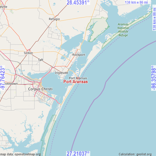
Port Aransas GPS coordinates[2]
27° 50' 2.112" North, 97° 3' 39.96" West
| Map corner | latitude | longitude |
|---|---|---|
| Upper-left | 28.45391°, | -97.76423° |
| Center: | 27.83392°, | -97.0611° |
| Lower-right: | 27.21037°, | -96.35798° |
| Map W x H: | 138.3×138.3 km | = 85.9×85.9mi |
| max Lat: | 71.29058° ⇑96.9% North |
| Port Aransas: | 27.83392° |
| min Lat: | ⇓3.1% South 19.06759° |
| min Long | Port Aransas | max Long |
| -171.73463° | -97.0611° | -66.98998° |
| W 24.1%⇐ | ⇒75.9% E |
Elevation
Elevation of Port Aransas is 6 m = 20 ft, and this is 288.8 m = 948 ft below average elevation for this country.
| Max E: |
3189 m = 10463 ft | 97.4% |
| Avg. | 294.8 m = 967 ft | |
| Port Aransas | 6 m = 20 ft | |
Min E: |
-60 m = -197 ft | 2.6% |
See also: United States elevation on elevation.city.
Geographical zone
Port Aransas is located in North temperate zone (between Tropic of Cancer and the Arctic Circle). Distance of this Northern Tropic circle is 488.9 km =303.8 mi to South.| Distance of | km | miles | from Port Aransas |
|---|---|---|---|
| North Pole | 6912.2 | 4295 | to North |
| Arctic Circle | 4306.3 | 2675.8 | to North |
| Tropic Cancer | 488.9 | 303.8 | to South |
| Equator | 3094.8 | 1923 | to South |


Nearby cities:
15 places around Port Aransas: (largest is in red/bold)
• Aransas Pass
12.1 km =7.5 mi,  313°
313°
• Corpus Christi
33.2 km =20.6 mi,  263°
263°
• Fulton
25.4 km =15.8 mi,  4°
4°
• Gregory
24.5 km =15.2 mi,  293°
293°
• Holiday Beach
37.6 km =23.4 mi,  7°
7°
• Ingleside
15.6 km =9.7 mi, 288°
• Ingleside On-the-Bay
16 km =9.9 mi,  268°
268°
• Lamar
34.4 km =21.4 mi, 9°
• Odem
52.8 km =32.8 mi,  284°
284°
• Portland
26.3 km =16.3 mi, 280°
• Rockport
20.8 km =12.9 mi, 1°
• Sinton
49.5 km =30.8 mi,  297°
297°
• Taft
36.9 km =22.9 mi, 295°
• Taft Southwest (historical)
37 km =23 mi, 294°
• Woodsboro
51.6 km =32.1 mi,  330°
330°
Sources, notices
• [Note1] Compared only with cities in United States existing in our database
• [Src1] Map data: © OpenStreetMap contributors (CC-BY-SA)
• [Src2] Other city data from geonames.org with taken over terms of usage.
• [Src3] Geographical zone / Annual Mean Temperature by Robert A. Rohde @ Wikipedia
