Lamar geodata
Lamar (Texas) is a populated place; located in United States in America/Chicago (GMT-5) time zone. With population of 636 people, there are 19302 cities with bigger population in this country. Compared to other cities in United States, 96.4% of cities are located further ↑North; 75.7% of cities are located further →East and 95.7% of cities have higher elevation than Lamar. Note1


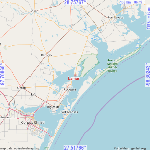
Lamar GPS coordinates[2]
28° 8' 22.056" North, 97° 0' 19.98" West
| Map corner | latitude | longitude |
|---|---|---|
| Upper-left | 28.75767°, | -97.70868° |
| Center: | 28.13946°, | -97.00555° |
| Lower-right: | 27.51766°, | -96.30243° |
| Map W x H: | 137.9×137.9 km | = 85.7×85.7mi |
| max Lat: | 71.29058° ⇑96.4% North |
| Lamar: | 28.13946° |
| min Lat: | ⇓3.6% South 19.06759° |
| min Long | Lamar | max Long |
| -171.73463° | -97.00555° | -66.98998° |
| W 24.3%⇐ | ⇒75.7% E |
Elevation
Elevation of Lamar is 8 m = 26 ft, and this is 286.8 m = 941 ft below average elevation for this country.
| Max E: |
3189 m = 10463 ft | 95.7% |
| Avg. | 294.8 m = 967 ft | |
| Lamar | 8 m = 26 ft | |
Min E: |
-60 m = -197 ft | 4.3% |
See also: United States elevation on elevation.city.
Geographical zone
Lamar is located in North temperate zone (between Tropic of Cancer and the Arctic Circle). Distance of this Northern Tropic circle is 522.9 km =324.9 mi to South.| Distance of | km | miles | from Lamar |
|---|---|---|---|
| North Pole | 6878.2 | 4273.9 | to North |
| Arctic Circle | 4272.4 | 2654.7 | to North |
| Tropic Cancer | 522.9 | 324.9 | to South |
| Equator | 3128.8 | 1944.1 | to South |


Nearby cities:
15 places around Lamar: (largest is in red/bold)
• Aransas Pass
29.2 km =18.1 mi,  209°
209°
• Fulton
9.4 km =5.8 mi,  201°
201°
• Gregory
36.9 km =22.9 mi,  229°
229°
• Holiday Beach
3.3 km =2.1 mi,  351°
351°
• Ingleside
35.4 km =22 mi, 214°
• Ingleside On-the-Bay
40.6 km =25.2 mi, 211°
• Port Aransas
34.4 km =21.4 mi,  189°
189°
• Portland
42.7 km =26.5 mi, 226°
• Refugio
32.2 km =20 mi,  304°
304°
• Rockport
14.1 km =8.8 mi, 200°
• Seadrift
41.9 km =26 mi,  42°
42°
• Sinton
50.7 km =31.5 mi,  256°
256°
• Taft
42.5 km =26.4 mi,  245°
245°
• Taft Southwest (historical)
43.1 km =26.8 mi,  244°
244°
• Woodsboro
32.7 km =20.3 mi,  289°
289°
Sources, notices
• [Note1] Compared only with cities in United States existing in our database
• [Src1] Map data: © OpenStreetMap contributors (CC-BY-SA)
• [Src2] Other city data from geonames.org with taken over terms of usage.
• [Src3] Geographical zone / Annual Mean Temperature by Robert A. Rohde @ Wikipedia
