Kilgore geodata
Kilgore (Texas) is a populated place; located in United States in America/Chicago (GMT-5) time zone. With population of 14,947 people, there are 3252 cities with bigger population in this country. Compared to other cities in United States, 87.6% of cities are located further ↑North; 70.8% of cities are located further →East and 67.3% of cities have higher elevation than Kilgore. Note1


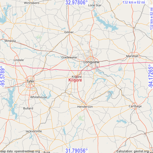
Kilgore GPS coordinates[2]
32° 23' 10.536" North, 94° 52' 32.772" West
| Map corner | latitude | longitude |
|---|---|---|
| Upper-left | 32.97806°, | -95.5789° |
| Center: | 32.38626°, | -94.87577° |
| Lower-right: | 31.79056°, | -94.17265° |
| Map W x H: | 132×132 km | = 82×82mi |
| max Lat: | 71.29058° ⇑87.6% North |
| Kilgore: | 32.38626° |
| min Lat: | ⇓12.4% South 19.06759° |
| min Long | Kilgore | max Long |
| -171.73463° | -94.87577° | -66.98998° |
| W 29.2%⇐ | ⇒70.8% E |
Elevation
Elevation of Kilgore is 116 m = 381 ft, and this is 178.8 m = 587 ft below average elevation for this country.
| Max E: |
3189 m = 10463 ft | 67.3% |
| Avg. | 294.8 m = 967 ft | |
| Kilgore | 116 m = 381 ft | |
Min E: |
-60 m = -197 ft | 32.7% |
See also: United States elevation on elevation.city.
Geographical zone
Kilgore is located in North temperate zone (between Tropic of Cancer and the Arctic Circle). Distance of this Northern Tropic circle is 995.1 km =618.3 mi to South.| Distance of | km | miles | from Kilgore |
|---|---|---|---|
| North Pole | 6406 | 3980.5 | to North |
| Arctic Circle | 3800.2 | 2361.3 | to North |
| Tropic Cancer | 995.1 | 618.3 | to South |
| Equator | 3601 | 2237.6 | to South |


Nearby cities:
15 places around Kilgore: (largest is in red/bold)
• Arp
24.7 km =15.3 mi,  223°
223°
• Big Sandy
31 km =19.3 mi,  315°
315°
• Clarksville City
16.1 km =10 mi,  350°
350°
• East Mountain
23.1 km =14.4 mi,  4°
4°
• Easton
27.5 km =17.1 mi,  89°
89°
• Gladewater
17.9 km =11.1 mi,  339°
339°
• Henderson
26.9 km =16.7 mi,  164°
164°
• Lakeport
16.2 km =10.1 mi,  81°
81°
• Liberty City
9.5 km =5.9 mi,  313°
313°
• Longview
18 km =11.2 mi,  44°
44°
• New Chapel Hill
29.3 km =18.2 mi,  252°
252°
• New London
17.5 km =10.9 mi,  200°
200°
• Overton
15.7 km =9.8 mi, 217°
• White Oak
15.8 km =9.8 mi, 4°
• Winona
29.7 km =18.5 mi,  292°
292°
Sources, notices
• [Note1] Compared only with cities in United States existing in our database
• [Src1] Map data: © OpenStreetMap contributors (CC-BY-SA)
• [Src2] Other city data from geonames.org with taken over terms of usage.
• [Src3] Geographical zone / Annual Mean Temperature by Robert A. Rohde @ Wikipedia
