Longview geodata
Longview (Texas) is a seat of a second-order administrative division; located in United States in America/Chicago (GMT-5) time zone. With population of 82,287 people, there are 476 cities with bigger population in this country. Compared to other cities in United States, 87.1% of cities are located further ↑North; 70.5% of cities are located further →East and 66.7% of cities have higher elevation than Longview. Note1


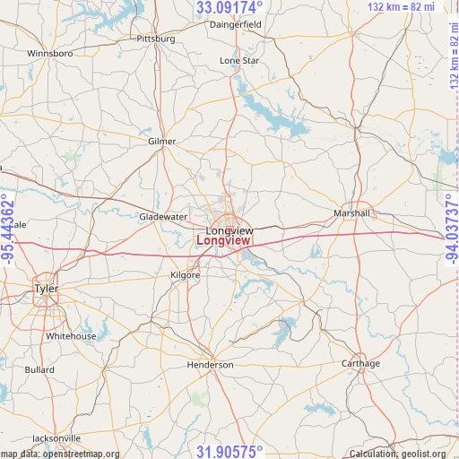
Longview GPS coordinates[2]
32° 30' 2.52" North, 94° 44' 25.764" West
| Map corner | latitude | longitude |
|---|---|---|
| Upper-left | 33.09174°, | -95.44362° |
| Center: | 32.5007°, | -94.74049° |
| Lower-right: | 31.90575°, | -94.03737° |
| Map W x H: | 131.9×131.9 km | = 82×82mi |
| max Lat: | 71.29058° ⇑87.1% North |
| Longview: | 32.5007° |
| min Lat: | ⇓12.9% South 19.06759° |
| min Long | Longview | max Long |
| -171.73463° | -94.74049° | -66.98998° |
| W 29.5%⇐ | ⇒70.5% E |
Elevation
Elevation of Longview is 119 m = 390 ft, and this is 175.8 m = 577 ft below average elevation for this country.
| Max E: |
3189 m = 10463 ft | 66.7% |
| Avg. | 294.8 m = 967 ft | |
| Longview | 119 m = 390 ft | |
Min E: |
-60 m = -197 ft | 33.3% |
See also: Longview elevation on elevation.city.
Geographical zone
Longview is located in North temperate zone (between Tropic of Cancer and the Arctic Circle). Distance of this Northern Tropic circle is 1007.8 km =626.2 mi to South.| Distance of | km | miles | from Longview |
|---|---|---|---|
| North Pole | 6393.3 | 3972.6 | to North |
| Arctic Circle | 3787.4 | 2353.4 | to North |
| Tropic Cancer | 1007.8 | 626.2 | to South |
| Equator | 3613.7 | 2245.4 | to South |


Nearby cities:
15 places around Longview: (largest is in red/bold)
• Clarksville City
15.6 km =9.7 mi,  281°
281°
• East Mountain
14.9 km =9.3 mi,  313°
313°
• Easton
19.4 km =12.1 mi,  130°
130°
• Gilmer
31.6 km =19.6 mi,  323°
323°
• Gladewater
19.4 km =12.1 mi, 281°
• Hallsville
15.6 km =9.7 mi,  88°
88°
• Kilgore
18 km =11.2 mi,  224°
224°
• Lakeport
10.7 km =6.6 mi,  162°
162°
• Liberty City
20.5 km =12.7 mi,  252°
252°
• Marshall
35.3 km =21.9 mi,  82°
82°
• New London
34.7 km =21.6 mi,  212°
212°
• Ore City
33.3 km =20.7 mi,  3°
3°
• Overton
33.6 km =20.9 mi, 221°
• Tatum
29.4 km =18.3 mi, 134°
• White Oak
11.7 km =7.3 mi, 284°
Sources, notices
• [Note1] Compared only with cities in United States existing in our database
• [Src1] Map data: © OpenStreetMap contributors (CC-BY-SA)
• [Src2] Other city data from geonames.org with taken over terms of usage.
• [Src3] Geographical zone / Annual Mean Temperature by Robert A. Rohde @ Wikipedia
