Winona geodata
Winona (Texas) is a populated place; located in United States in America/Chicago (GMT-5) time zone. With population of 598 people, there are 19725 cities with bigger population in this country. Compared to other cities in United States, 87.2% of cities are located further ↑North; 71.5% of cities are located further →East and 68.8% of cities have higher elevation than Winona. Note1


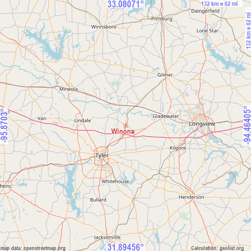
Winona GPS coordinates[2]
32° 29' 22.524" North, 95° 10' 1.812" West
| Map corner | latitude | longitude |
|---|---|---|
| Upper-left | 33.08071°, | -95.8703° |
| Center: | 32.48959°, | -95.16717° |
| Lower-right: | 31.89456°, | -94.46405° |
| Map W x H: | 131.9×131.9 km | = 82×82mi |
| max Lat: | 71.29058° ⇑87.2% North |
| Winona: | 32.48959° |
| min Lat: | ⇓12.8% South 19.06759° |
| min Long | Winona | max Long |
| -171.73463° | -95.16717° | -66.98998° |
| W 28.5%⇐ | ⇒71.5% E |
Elevation
Elevation of Winona is 108 m = 354 ft, and this is 186.8 m = 613 ft below average elevation for this country.
| Max E: |
3189 m = 10463 ft | 68.8% |
| Avg. | 294.8 m = 967 ft | |
| Winona | 108 m = 354 ft | |
Min E: |
-60 m = -197 ft | 31.2% |
See also: United States elevation on elevation.city.
Geographical zone
Winona is located in North temperate zone (between Tropic of Cancer and the Arctic Circle). Distance of this Northern Tropic circle is 1006.6 km =625.5 mi to South.| Distance of | km | miles | from Winona |
|---|---|---|---|
| North Pole | 6394.6 | 3973.4 | to North |
| Arctic Circle | 3788.7 | 2354.2 | to North |
| Tropic Cancer | 1006.6 | 625.5 | to South |
| Equator | 3612.5 | 2244.7 | to South |


Nearby cities:
15 places around Winona: (largest is in red/bold)
• Arp
31.1 km =19.3 mi,  160°
160°
• Big Sandy
11.8 km =7.3 mi,  27°
27°
• Clarksville City
25.2 km =15.7 mi,  79°
79°
• Gladewater
21.7 km =13.5 mi, 76°
• Hawkins
11.5 km =7.1 mi,  342°
342°
• Hideaway
27.2 km =16.9 mi,  270°
270°
• Holly Lake Ranch
25 km =15.5 mi,  353°
353°
• Kilgore
29.7 km =18.5 mi,  112°
112°
• Liberty City
21.1 km =13.1 mi,  103°
103°
• Lindale
22.9 km =14.2 mi,  277°
277°
• New Chapel Hill
20.5 km =12.7 mi,  181°
181°
• Overton
29.8 km =18.5 mi,  143°
143°
• Tyler
19.9 km =12.4 mi,  219°
219°
• White Oak
29 km =18 mi, 81°
• Whitehouse
29.7 km =18.5 mi,  190°
190°
Sources, notices
• [Note1] Compared only with cities in United States existing in our database
• [Src1] Map data: © OpenStreetMap contributors (CC-BY-SA)
• [Src2] Other city data from geonames.org with taken over terms of usage.
• [Src3] Geographical zone / Annual Mean Temperature by Robert A. Rohde @ Wikipedia
