Temple geodata
Temple (Texas) is a populated place; located in United States in America/Chicago (GMT-5) time zone. With population of 72,277 people, there are 568 cities with bigger population in this country. Compared to other cities in United States, 90.5% of cities are located further ↑North; 76.7% of cities are located further →East and 56.1% of cities have lower elevation than Temple. Note1


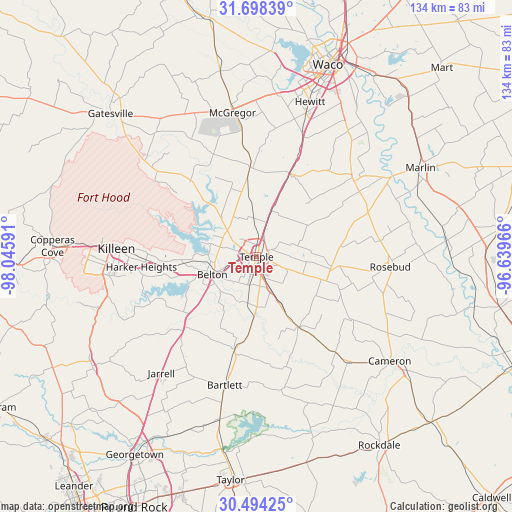
Temple GPS coordinates[2]
31° 5' 53.628" North, 97° 20' 34.008" West
| Map corner | latitude | longitude |
|---|---|---|
| Upper-left | 31.69839°, | -98.04591° |
| Center: | 31.09823°, | -97.34278° |
| Lower-right: | 30.49425°, | -96.63966° |
| Map W x H: | 133.9×133.9 km | = 83.2×83.2mi |
| max Lat: | 71.29058° ⇑90.5% North |
| Temple: | 31.09823° |
| min Lat: | ⇓9.5% South 19.06759° |
| min Long | Temple | max Long |
| -171.73463° | -97.34278° | -66.98998° |
| W 23.3%⇐ | ⇒76.7% E |
Elevation
Elevation of Temple is 223 m = 732 ft, and this is 71.8 m = 236 ft below average elevation for this country.
| Max E: |
3189 m = 10463 ft | 43.9% |
| Avg. | 294.8 m = 967 ft | |
| Temple | 223 m = 732 ft | |
Min E: |
-60 m = -197 ft | 56.1% |
See also: Temple elevation on elevation.city.
Geographical zone
Temple is located in North temperate zone (between Tropic of Cancer and the Arctic Circle). Distance of this Northern Tropic circle is 851.9 km =529.3 mi to South.| Distance of | km | miles | from Temple |
|---|---|---|---|
| North Pole | 6549.3 | 4069.5 | to North |
| Arctic Circle | 3943.4 | 2450.3 | to North |
| Tropic Cancer | 851.9 | 529.3 | to South |
| Equator | 3457.8 | 2148.6 | to South |


Nearby cities:
15 places around Temple: (largest is in red/bold)
• Belton
12.5 km =7.8 mi,  247°
247°
• Bruceville-Eddy
24.6 km =15.3 mi,  20°
20°
• Buckholts
32.5 km =20.2 mi,  140°
140°
• Chilton
33.3 km =20.7 mi,  52°
52°
• Harker Heights
30.2 km =18.8 mi,  266°
266°
• Holland
25.1 km =15.6 mi,  192°
192°
• Little River-Academy
12.5 km =7.8 mi, 186°
• Lott
31.4 km =19.5 mi,  68°
68°
• Moody
23.4 km =14.5 mi,  355°
355°
• Morgans Point Resort
12.8 km =8 mi,  295°
295°
• Nolanville
25.1 km =15.6 mi, 265°
• Rogers
21.6 km =13.4 mi,  149°
149°
• Salado
25.1 km =15.6 mi,  228°
228°
• Sparks
18.9 km =11.7 mi,  184°
184°
• Troy
12.7 km =7.9 mi, 17°
Sources, notices
• [Note1] Compared only with cities in United States existing in our database
• [Src1] Map data: © OpenStreetMap contributors (CC-BY-SA)
• [Src2] Other city data from geonames.org with taken over terms of usage.
• [Src3] Geographical zone / Annual Mean Temperature by Robert A. Rohde @ Wikipedia
