Lowry Crossing geodata
Lowry Crossing (Texas) is a populated place; located in United States in America/Chicago (GMT-5) time zone. With population of 1,780 people, there are 12625 cities with bigger population in this country. Compared to other cities in United States, 84.5% of cities are located further ↑North; 74.6% of cities are located further →East and 59% of cities have higher elevation than Lowry Crossing. Note1


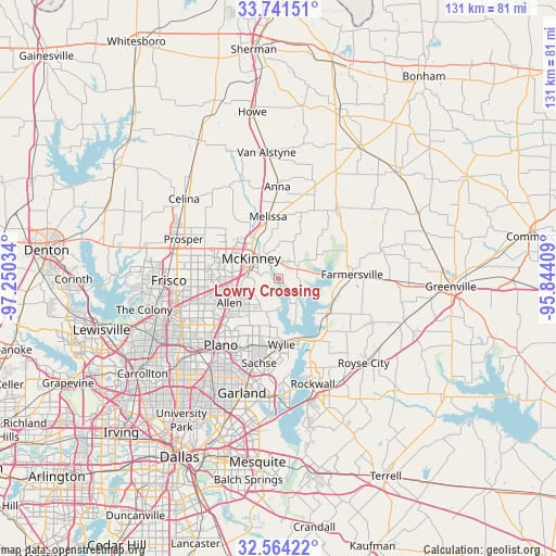
Lowry Crossing GPS coordinates[2]
33° 9' 17.424" North, 96° 32' 49.956" West
| Map corner | latitude | longitude |
|---|---|---|
| Upper-left | 33.74151°, | -97.25034° |
| Center: | 33.15484°, | -96.54721° |
| Lower-right: | 32.56422°, | -95.84409° |
| Map W x H: | 130.9×130.9 km | = 81.3×81.3mi |
| max Lat: | 71.29058° ⇑84.5% North |
| Lowry Crossing: | 33.15484° |
| min Lat: | ⇓15.5% South 19.06759° |
| min Long | Lowry Crossing | max Long |
| -171.73463° | -96.54721° | -66.98998° |
| W 25.4%⇐ | ⇒74.6% E |
Elevation
Elevation of Lowry Crossing is 160 m = 525 ft, and this is 134.8 m = 442 ft below average elevation for this country.
| Max E: |
3189 m = 10463 ft | 59% |
| Avg. | 294.8 m = 967 ft | |
| Lowry Crossing | 160 m = 525 ft | |
Min E: |
-60 m = -197 ft | 41% |
See also: United States elevation on elevation.city.
Geographical zone
Lowry Crossing is located in North temperate zone (between Tropic of Cancer and the Arctic Circle). Distance of this Northern Tropic circle is 1080.6 km =671.5 mi to South.| Distance of | km | miles | from Lowry Crossing |
|---|---|---|---|
| North Pole | 6320.6 | 3927.4 | to North |
| Arctic Circle | 3714.7 | 2308.2 | to North |
| Tropic Cancer | 1080.6 | 671.5 | to South |
| Equator | 3686.5 | 2290.7 | to South |


Nearby cities:
15 places around Lowry Crossing: (largest is in red/bold)
• Allen
12.8 km =8 mi,  243°
243°
• Fairview
7.9 km =4.9 mi,  272°
272°
• Farmersville
17.5 km =10.9 mi,  86°
86°
• Lavon
17.6 km =10.9 mi,  143°
143°
• Lucas
8.3 km =5.2 mi,  199°
199°
• McKinney
7.9 km =4.9 mi,  306°
306°
• Melissa
14.8 km =9.2 mi,  350°
350°
• Murphy
16.7 km =10.4 mi, 201°
• Nevada
20.4 km =12.7 mi,  127°
127°
• New Hope
6.4 km =4 mi,  344°
344°
• Parker
13.1 km =8.1 mi,  212°
212°
• Princeton
5.4 km =3.4 mi,  58°
58°
• Sachse
20.4 km =12.7 mi,  192°
192°
• Saint Paul
12.6 km =7.8 mi,  181°
181°
• Wylie
15.6 km =9.7 mi, 177°
Sources, notices
• [Note1] Compared only with cities in United States existing in our database
• [Src1] Map data: © OpenStreetMap contributors (CC-BY-SA)
• [Src2] Other city data from geonames.org with taken over terms of usage.
• [Src3] Geographical zone / Annual Mean Temperature by Robert A. Rohde @ Wikipedia
