New Hope geodata
New Hope (Texas) is a populated place; located in United States in America/Chicago (GMT-5) time zone. With population of 639 people, there are 19276 cities with bigger population in this country. Compared to other cities in United States, 84.3% of cities are located further ↑North; 74.6% of cities are located further →East and 52.5% of cities have higher elevation than New Hope. Note1


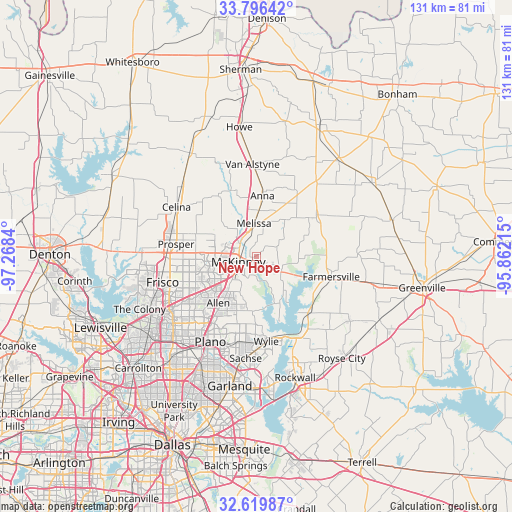
New Hope GPS coordinates[2]
33° 12' 36.432" North, 96° 33' 54.972" West
| Map corner | latitude | longitude |
|---|---|---|
| Upper-left | 33.79642°, | -97.2684° |
| Center: | 33.21012°, | -96.56527° |
| Lower-right: | 32.61987°, | -95.86215° |
| Map W x H: | 130.8×130.8 km | = 81.3×81.3mi |
| max Lat: | 71.29058° ⇑84.3% North |
| New Hope: | 33.21012° |
| min Lat: | ⇓15.7% South 19.06759° |
| min Long | New Hope | max Long |
| -171.73463° | -96.56527° | -66.98998° |
| W 25.4%⇐ | ⇒74.6% E |
Elevation
Elevation of New Hope is 189 m = 620 ft, and this is 105.8 m = 347 ft below average elevation for this country.
| Max E: |
3189 m = 10463 ft | 52.5% |
| Avg. | 294.8 m = 967 ft | |
| New Hope | 189 m = 620 ft | |
Min E: |
-60 m = -197 ft | 47.5% |
See also: United States elevation on elevation.city.
Geographical zone
New Hope is located in North temperate zone (between Tropic of Cancer and the Arctic Circle). Distance of this Northern Tropic circle is 1086.7 km =675.2 mi to South.| Distance of | km | miles | from New Hope |
|---|---|---|---|
| North Pole | 6314.4 | 3923.6 | to North |
| Arctic Circle | 3708.6 | 2304.4 | to North |
| Tropic Cancer | 1086.7 | 675.2 | to South |
| Equator | 3692.6 | 2294.5 | to South |


Nearby cities:
15 places around New Hope: (largest is in red/bold)
• Allen
15.4 km =9.6 mi,  219°
219°
• Anna
15.5 km =9.6 mi,  5°
5°
• Blue Ridge
18.1 km =11.2 mi,  57°
57°
• Fairview
8.5 km =5.3 mi,  226°
226°
• Farmersville
19.8 km =12.3 mi,  105°
105°
• Lowry Crossing
6.4 km =4 mi,  164°
164°
• Lucas
14 km =8.7 mi,  184°
184°
• McKinney
4.9 km =3 mi,  253°
253°
• Melissa
8.5 km =5.3 mi,  355°
355°
• Murphy
22.1 km =13.7 mi,  191°
191°
• Parker
18 km =11.2 mi,  197°
197°
• Princeton
7.1 km =4.4 mi,  118°
118°
• Saint Paul
18.8 km =11.7 mi, 175°
• Westminster
19.5 km =12.1 mi,  29°
29°
• Wylie
21.8 km =13.5 mi,  173°
173°
Sources, notices
• [Note1] Compared only with cities in United States existing in our database
• [Src1] Map data: © OpenStreetMap contributors (CC-BY-SA)
• [Src2] Other city data from geonames.org with taken over terms of usage.
• [Src3] Geographical zone / Annual Mean Temperature by Robert A. Rohde @ Wikipedia
