Melissa geodata
Melissa (Texas) is a populated place; located in United States in America/Chicago (GMT-5) time zone. With population of 7,436 people, there are 5573 cities with bigger population in this country. Compared to other cities in United States, 84% of cities are located further ↑North; 74.6% of cities are located further →East and 53.2% of cities have lower elevation than Melissa. Note1


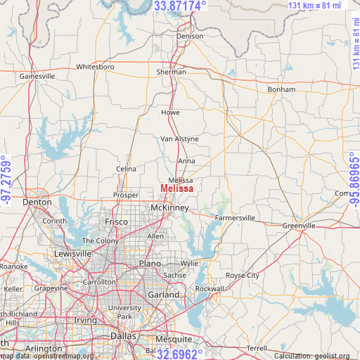
Melissa GPS coordinates[2]
33° 17' 9.42" North, 96° 34' 21.972" West
| Map corner | latitude | longitude |
|---|---|---|
| Upper-left | 33.87174°, | -97.2759° |
| Center: | 33.28595°, | -96.57277° |
| Lower-right: | 32.6962°, | -95.86965° |
| Map W x H: | 130.7×130.7 km | = 81.2×81.2mi |
| max Lat: | 71.29058° ⇑84% North |
| Melissa: | 33.28595° |
| min Lat: | ⇓16% South 19.06759° |
| min Long | Melissa | max Long |
| -171.73463° | -96.57277° | -66.98998° |
| W 25.4%⇐ | ⇒74.6% E |
Elevation
Elevation of Melissa is 211 m = 692 ft, and this is 83.8 m = 275 ft below average elevation for this country.
| Max E: |
3189 m = 10463 ft | 46.8% |
| Avg. | 294.8 m = 967 ft | |
| Melissa | 211 m = 692 ft | |
Min E: |
-60 m = -197 ft | 53.2% |
See also: United States elevation on elevation.city.
Geographical zone
Melissa is located in North temperate zone (between Tropic of Cancer and the Arctic Circle). Distance of this Northern Tropic circle is 1095.1 km =680.5 mi to South.| Distance of | km | miles | from Melissa |
|---|---|---|---|
| North Pole | 6306 | 3918.4 | to North |
| Arctic Circle | 3700.1 | 2299.1 | to North |
| Tropic Cancer | 1095.1 | 680.5 | to South |
| Equator | 3701.1 | 2299.8 | to South |


Nearby cities:
15 places around Melissa: (largest is in red/bold)
• Allen
22.3 km =13.9 mi,  204°
204°
• Anna
7.4 km =4.6 mi,  17°
17°
• Blue Ridge
16 km =9.9 mi,  85°
85°
• Celina
20.1 km =12.5 mi,  282°
282°
• Fairview
15.3 km =9.5 mi, 201°
• Farmersville
24 km =14.9 mi,  124°
124°
• Gunter
24.2 km =15 mi,  317°
317°
• Lowry Crossing
14.8 km =9.2 mi,  170°
170°
• Lucas
22.4 km =13.9 mi,  180°
180°
• McKinney
10.6 km =6.6 mi, 201°
• New Hope
8.5 km =5.3 mi, 175°
• Princeton
13.7 km =8.5 mi,  149°
149°
• Prosper
21.9 km =13.6 mi,  255°
255°
• Van Alstyne
15.1 km =9.4 mi,  358°
358°
• Westminster
13.4 km =8.3 mi,  50°
50°
Sources, notices
• [Note1] Compared only with cities in United States existing in our database
• [Src1] Map data: © OpenStreetMap contributors (CC-BY-SA)
• [Src2] Other city data from geonames.org with taken over terms of usage.
• [Src3] Geographical zone / Annual Mean Temperature by Robert A. Rohde @ Wikipedia
