Nevada geodata
Nevada (Texas) is a populated place; located in United States in America/Chicago (GMT-5) time zone. With population of 1,008 people, there are 16234 cities with bigger population in this country. Compared to other cities in United States, 85% of cities are located further ↑North; 74.2% of cities are located further →East and 50.5% of cities have lower elevation than Nevada. Note1


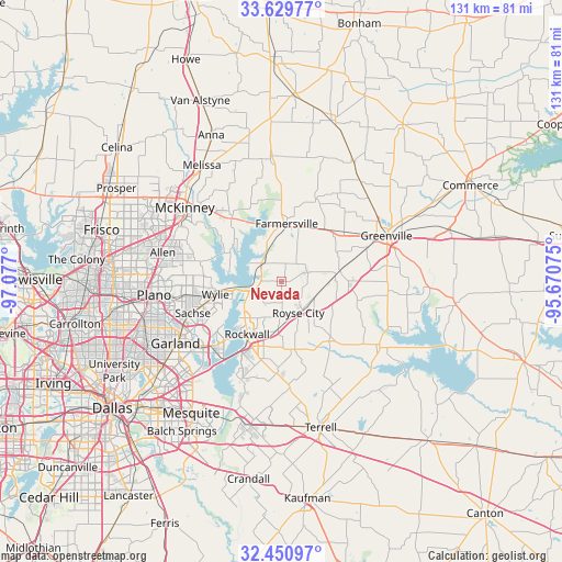
Nevada GPS coordinates[2]
33° 2' 32.424" North, 96° 22' 25.932" West
| Map corner | latitude | longitude |
|---|---|---|
| Upper-left | 33.62977°, | -97.077° |
| Center: | 33.04234°, | -96.37387° |
| Lower-right: | 32.45097°, | -95.67075° |
| Map W x H: | 131.1×131.1 km | = 81.5×81.5mi |
| max Lat: | 71.29058° ⇑85% North |
| Nevada: | 33.04234° |
| min Lat: | ⇓15% South 19.06759° |
| min Long | Nevada | max Long |
| -171.73463° | -96.37387° | -66.98998° |
| W 25.8%⇐ | ⇒74.2% E |
Elevation
Elevation of Nevada is 200 m = 656 ft, and this is 94.8 m = 311 ft below average elevation for this country.
| Max E: |
3189 m = 10463 ft | 49.5% |
| Avg. | 294.8 m = 967 ft | |
| Nevada | 200 m = 656 ft | |
Min E: |
-60 m = -197 ft | 50.5% |
See also: United States elevation on elevation.city.
Geographical zone
Nevada is located in North temperate zone (between Tropic of Cancer and the Arctic Circle). Distance of this Northern Tropic circle is 1068 km =663.6 mi to South.| Distance of | km | miles | from Nevada |
|---|---|---|---|
| North Pole | 6333.1 | 3935.2 | to North |
| Arctic Circle | 3727.2 | 2316 | to North |
| Tropic Cancer | 1068 | 663.6 | to South |
| Equator | 3674 | 2282.9 | to South |


Nearby cities:
15 places around Nevada: (largest is in red/bold)
• Caddo Mills
13.9 km =8.6 mi,  79°
79°
• Farmersville
13.5 km =8.4 mi,  5°
5°
• Fate
11.2 km =7 mi,  183°
183°
• Josephine
6.6 km =4.1 mi,  71°
71°
• Lavon
5.9 km =3.7 mi,  253°
253°
• Lowry Crossing
20.4 km =12.7 mi,  307°
307°
• Lucas
19.5 km =12.1 mi,  283°
283°
• McLendon-Chisholm
22.2 km =13.8 mi, 181°
• Murphy
22.5 km =14 mi,  262°
262°
• Princeton
19.2 km =11.9 mi,  322°
322°
• Rockwall
14.7 km =9.1 mi,  212°
212°
• Royse City
8.4 km =5.2 mi,  152°
152°
• Sachse
21.9 km =13.6 mi, 250°
• Saint Paul
16.4 km =10.2 mi,  269°
269°
• Wylie
15.7 km =9.8 mi, 258°
Sources, notices
• [Note1] Compared only with cities in United States existing in our database
• [Src1] Map data: © OpenStreetMap contributors (CC-BY-SA)
• [Src2] Other city data from geonames.org with taken over terms of usage.
• [Src3] Geographical zone / Annual Mean Temperature by Robert A. Rohde @ Wikipedia
