Anna geodata
Anna (Texas) is a populated place; located in United States in America/Chicago (GMT-5) time zone. With population of 11,463 people, there are 4035 cities with bigger population in this country. Compared to other cities in United States, 83.8% of cities are located further ↑North; 74.6% of cities are located further →East and 55.6% of cities have lower elevation than Anna. Note1


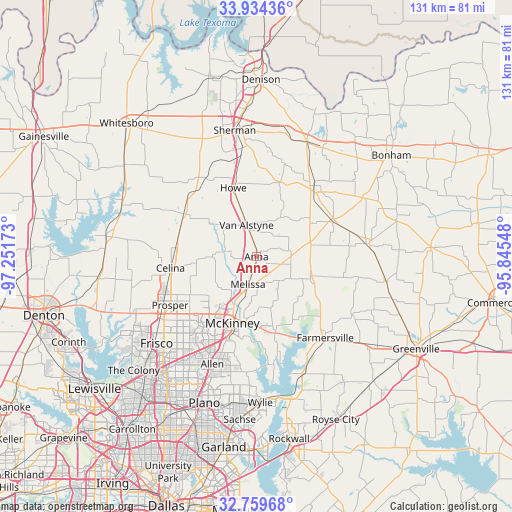
Anna GPS coordinates[2]
33° 20' 56.4" North, 96° 32' 54.96" West
| Map corner | latitude | longitude |
|---|---|---|
| Upper-left | 33.93436°, | -97.25173° |
| Center: | 33.349°, | -96.5486° |
| Lower-right: | 32.75968°, | -95.84548° |
| Map W x H: | 130.6×130.6 km | = 81.2×81.2mi |
| max Lat: | 71.29058° ⇑83.8% North |
| Anna: | 33.349° |
| min Lat: | ⇓16.2% South 19.06759° |
| min Long | Anna | max Long |
| -171.73463° | -96.5486° | -66.98998° |
| W 25.4%⇐ | ⇒74.6% E |
Elevation
Elevation of Anna is 221 m = 725 ft, and this is 73.8 m = 242 ft below average elevation for this country.
| Max E: |
3189 m = 10463 ft | 44.4% |
| Avg. | 294.8 m = 967 ft | |
| Anna | 221 m = 725 ft | |
Min E: |
-60 m = -197 ft | 55.6% |
See also: United States elevation on elevation.city.
Geographical zone
Anna is located in North temperate zone (between Tropic of Cancer and the Arctic Circle). Distance of this Northern Tropic circle is 1102.1 km =684.8 mi to South.| Distance of | km | miles | from Anna |
|---|---|---|---|
| North Pole | 6299 | 3914 | to North |
| Arctic Circle | 3693.1 | 2294.8 | to North |
| Tropic Cancer | 1102.1 | 684.8 | to South |
| Equator | 3708.1 | 2304.1 | to South |


Nearby cities:
15 places around Anna: (largest is in red/bold)
• Blue Ridge
14.8 km =9.2 mi,  112°
112°
• Celina
22.1 km =13.7 mi,  262°
262°
• Fairview
22.6 km =14 mi,  199°
199°
• Gunter
21.5 km =13.4 mi,  300°
300°
• Howe
18.7 km =11.6 mi,  341°
341°
• Lowry Crossing
21.6 km =13.4 mi,  179°
179°
• McKinney
17.9 km =11.1 mi, 200°
• Melissa
7.4 km =4.6 mi, 197°
• New Hope
15.5 km =9.6 mi,  185°
185°
• Princeton
19.4 km =12.1 mi,  165°
165°
• Tom Bean
20 km =12.4 mi,  17°
17°
• Trenton
21.5 km =13.4 mi,  65°
65°
• Van Alstyne
8.5 km =5.3 mi, 341°
• Westminster
8.2 km =5.1 mi,  79°
79°
• Whitewright
23.3 km =14.5 mi,  38°
38°
Sources, notices
• [Note1] Compared only with cities in United States existing in our database
• [Src1] Map data: © OpenStreetMap contributors (CC-BY-SA)
• [Src2] Other city data from geonames.org with taken over terms of usage.
• [Src3] Geographical zone / Annual Mean Temperature by Robert A. Rohde @ Wikipedia
