McLendon-Chisholm geodata
McLendon-Chisholm (Texas) is a populated place; located in United States in America/Chicago (GMT-5) time zone. With population of 2,210 people, there are 11312 cities with bigger population in this country. Compared to other cities in United States, 85.8% of cities are located further ↑North; 74.2% of cities are located further →East and 59.3% of cities have higher elevation than McLendon-Chisholm. Note1


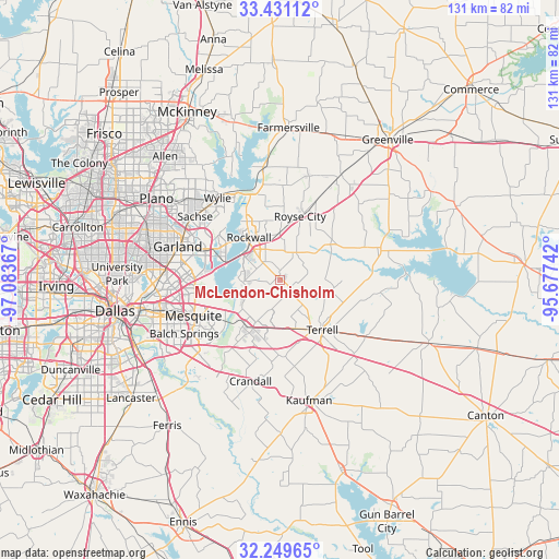
McLendon-Chisholm GPS coordinates[2]
32° 50' 32.46" North, 96° 22' 49.944" West
| Map corner | latitude | longitude |
|---|---|---|
| Upper-left | 33.43112°, | -97.08367° |
| Center: | 32.84235°, | -96.38054° |
| Lower-right: | 32.24965°, | -95.67742° |
| Map W x H: | 131.4×131.4 km | = 81.6×81.6mi |
| max Lat: | 71.29058° ⇑85.8% North |
| McLendon-Chisholm: | 32.84235° |
| min Lat: | ⇓14.2% South 19.06759° |
| min Long | McLendon-Chisho | max Long |
| -171.73463° | -96.38054° | -66.98998° |
| W 25.8%⇐ | ⇒74.2% E |
Elevation
Elevation of McLendon-Chisholm is 158 m = 518 ft, and this is 136.8 m = 449 ft below average elevation for this country.
| Max E: |
3189 m = 10463 ft | 59.3% |
| Avg. | 294.8 m = 967 ft | |
| McLendon-Chisholm | 158 m = 518 ft | |
Min E: |
-60 m = -197 ft | 40.7% |
See also: United States elevation on elevation.city.
Geographical zone
McLendon-Chisholm is located in North temperate zone (between Tropic of Cancer and the Arctic Circle). Distance of this Northern Tropic circle is 1045.8 km =649.8 mi to South.| Distance of | km | miles | from McLendon-Chisholm |
|---|---|---|---|
| North Pole | 6355.3 | 3949 | to North |
| Arctic Circle | 3749.4 | 2329.8 | to North |
| Tropic Cancer | 1045.8 | 649.8 | to South |
| Equator | 3651.7 | 2269.1 | to South |


Nearby cities:
15 places around McLendon-Chisholm: (largest is in red/bold)
• Fate
11 km =6.8 mi,  359°
359°
• Forney
13.5 km =8.4 mi,  219°
219°
• Heath
8.8 km =5.5 mi,  265°
265°
• Lavon
21.2 km =13.2 mi,  346°
346°
• Mesquite
22.1 km =13.7 mi,  247°
247°
• Nevada
22.2 km =13.8 mi,  1°
1°
• Oak Ridge
23.4 km =14.5 mi,  151°
151°
• Quinlan
24.1 km =15 mi,  71°
71°
• Rockwall
12.3 km =7.6 mi,  323°
323°
• Rowlett
18.4 km =11.4 mi,  291°
291°
• Royse City
15.4 km =9.6 mi,  16°
16°
• Sunnyvale
17.6 km =10.9 mi, 253°
• Talty
17.7 km =11 mi,  181°
181°
• Terrell
15.4 km =9.6 mi,  140°
140°
• Travis Ranch
9.7 km =6 mi,  243°
243°
Sources, notices
• [Note1] Compared only with cities in United States existing in our database
• [Src1] Map data: © OpenStreetMap contributors (CC-BY-SA)
• [Src2] Other city data from geonames.org with taken over terms of usage.
• [Src3] Geographical zone / Annual Mean Temperature by Robert A. Rohde @ Wikipedia
