Rockwall geodata
Rockwall (Texas) is a seat of a second-order administrative division; located in United States in America/Chicago (GMT-5) time zone. With population of 42,566 people, there are 1127 cities with bigger population in this country. Compared to other cities in United States, 85.4% of cities are located further ↑North; 74.3% of cities are located further →East and 53.9% of cities have higher elevation than Rockwall. Note1


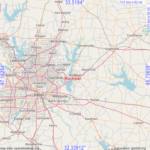
Rockwall GPS coordinates[2]
32° 55' 52.428" North, 96° 27' 34.956" West
| Map corner | latitude | longitude |
|---|---|---|
| Upper-left | 33.5194°, | -97.16284° |
| Center: | 32.93123°, | -96.45971° |
| Lower-right: | 32.33912°, | -95.75659° |
| Map W x H: | 131.2×131.2 km | = 81.5×81.5mi |
| max Lat: | 71.29058° ⇑85.4% North |
| Rockwall: | 32.93123° |
| min Lat: | ⇓14.6% South 19.06759° |
| min Long | Rockwall | max Long |
| -171.73463° | -96.45971° | -66.98998° |
| W 25.7%⇐ | ⇒74.3% E |
Elevation
Elevation of Rockwall is 184 m = 604 ft, and this is 110.8 m = 364 ft below average elevation for this country.
| Max E: |
3189 m = 10463 ft | 53.9% |
| Avg. | 294.8 m = 967 ft | |
| Rockwall | 184 m = 604 ft | |
Min E: |
-60 m = -197 ft | 46.1% |
See also: Rockwall elevation on elevation.city.
Geographical zone
Rockwall is located in North temperate zone (between Tropic of Cancer and the Arctic Circle). Distance of this Northern Tropic circle is 1055.7 km =656 mi to South.| Distance of | km | miles | from Rockwall |
|---|---|---|---|
| North Pole | 6345.5 | 3942.9 | to North |
| Arctic Circle | 3739.6 | 2323.7 | to North |
| Tropic Cancer | 1055.7 | 656 | to South |
| Equator | 3661.6 | 2275.2 | to South |


Nearby cities:
15 places around Rockwall: (largest is in red/bold)
• Fate
7.4 km =4.6 mi,  81°
81°
• Garland
16.9 km =10.5 mi,  262°
262°
• Heath
10.6 km =6.6 mi,  187°
187°
• Lavon
11 km =6.8 mi,  12°
12°
• Lucas
20.2 km =12.6 mi,  327°
327°
• McLendon-Chisholm
12.3 km =7.6 mi,  143°
143°
• Murphy
17.1 km =10.6 mi,  303°
303°
• Nevada
14.7 km =9.1 mi,  32°
32°
• Rowlett
10.2 km =6.3 mi,  252°
252°
• Royse City
12.8 km =8 mi,  67°
67°
• Sachse
13.6 km =8.5 mi,  291°
291°
• Saint Paul
14.9 km =9.3 mi, 325°
• Sunnyvale
17.7 km =11 mi,  212°
212°
• Travis Ranch
14.3 km =8.9 mi, 185°
• Wylie
11.9 km =7.4 mi,  321°
321°
Sources, notices
• [Note1] Compared only with cities in United States existing in our database
• [Src1] Map data: © OpenStreetMap contributors (CC-BY-SA)
• [Src2] Other city data from geonames.org with taken over terms of usage.
• [Src3] Geographical zone / Annual Mean Temperature by Robert A. Rohde @ Wikipedia
