Oak Ridge geodata
Oak Ridge (Texas) is a populated place; located in United States in America/Chicago (GMT-5) time zone. With population of 575 people, there are 19968 cities with bigger population in this country. Compared to other cities in United States, 86.6% of cities are located further ↑North; 74% of cities are located further →East and 63.7% of cities have higher elevation than Oak Ridge. Note1


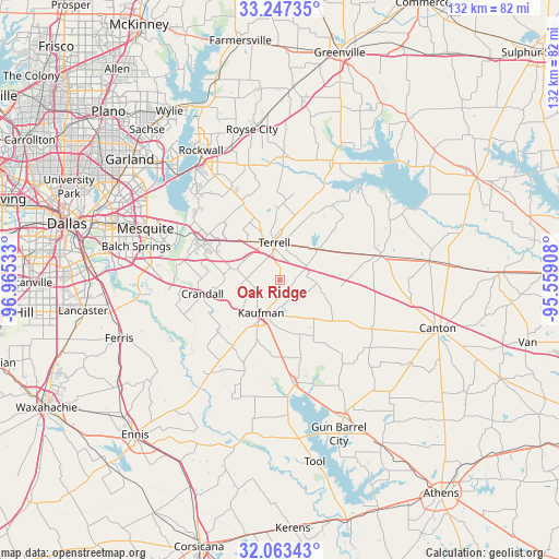
Oak Ridge GPS coordinates[2]
32° 39' 26.46" North, 96° 15' 43.92" West
| Map corner | latitude | longitude |
|---|---|---|
| Upper-left | 33.24735°, | -96.96533° |
| Center: | 32.65735°, | -96.2622° |
| Lower-right: | 32.06343°, | -95.55908° |
| Map W x H: | 131.6×131.6 km | = 81.8×81.8mi |
| max Lat: | 71.29058° ⇑86.6% North |
| Oak Ridge: | 32.65735° |
| min Lat: | ⇓13.4% South 19.06759° |
| min Long | Oak Ridge | max Long |
| -171.73463° | -96.2622° | -66.98998° |
| W 26%⇐ | ⇒74% E |
Elevation
Elevation of Oak Ridge is 135 m = 443 ft, and this is 159.8 m = 524 ft below average elevation for this country.
| Max E: |
3189 m = 10463 ft | 63.7% |
| Avg. | 294.8 m = 967 ft | |
| Oak Ridge | 135 m = 443 ft | |
Min E: |
-60 m = -197 ft | 36.3% |
See also: United States elevation on elevation.city.
Geographical zone
Oak Ridge is located in North temperate zone (between Tropic of Cancer and the Arctic Circle). Distance of this Northern Tropic circle is 1025.2 km =637 mi to South.| Distance of | km | miles | from Oak Ridge |
|---|---|---|---|
| North Pole | 6375.9 | 3961.8 | to North |
| Arctic Circle | 3770 | 2342.6 | to North |
| Tropic Cancer | 1025.2 | 637 | to South |
| Equator | 3631.2 | 2256.3 | to South |


Nearby cities:
15 places around Oak Ridge: (largest is in red/bold)
• Combine
24.3 km =15.1 mi,  251°
251°
• Crandall
18.4 km =11.4 mi,  259°
259°
• Elmo
11.6 km =7.2 mi,  51°
51°
• Forney
22.1 km =13.7 mi,  297°
297°
• Kaufman
8.8 km =5.5 mi,  209°
209°
• Kemp
24.1 km =15 mi,  172°
172°
• McLendon-Chisholm
23.4 km =14.5 mi,  331°
331°
• Oak Grove
14.6 km =9.1 mi,  201°
201°
• Post Oak Bend City
5.6 km =3.5 mi,  239°
239°
• Scurry
19 km =11.8 mi,  215°
215°
• Seagoville
25.9 km =16.1 mi,  265°
265°
• Talty
11.9 km =7.4 mi,  283°
283°
• Terrell
8.8 km =5.5 mi,  352°
352°
• Travis Ranch
25.6 km =15.9 mi,  309°
309°
• Wills Point
24.5 km =15.2 mi,  76°
76°
Sources, notices
• [Note1] Compared only with cities in United States existing in our database
• [Src1] Map data: © OpenStreetMap contributors (CC-BY-SA)
• [Src2] Other city data from geonames.org with taken over terms of usage.
• [Src3] Geographical zone / Annual Mean Temperature by Robert A. Rohde @ Wikipedia
